
 Bangladesh Defense
Saif
Senior Member
- Jan 24, 2024
- 21,561
- 9,760
- Nation

- Residence
- Axis Group


Rethinking canal dredging to improve flood management
As another monsoon season approaches, the government’s current canal dredging programme can be a core option for flood preparedness.
Rethinking canal dredging to improve flood management
Md. Abdullah Al Baky
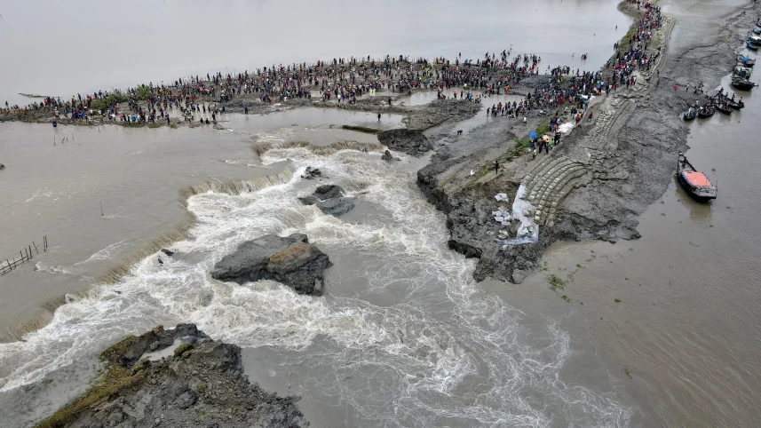
Overflowing river water washed away part of a coastal dyke in Khulna during the devastating flood of August 2024. FILE PHOTO: HABIBUR RAHMAN
As another monsoon season approaches, the government’s current canal dredging programme can be a core option for flood preparedness. The aim of the programme is clear: restore drainage, reduce waterlogging, and allow floodwaters to recede faster. But the real question is deeper: can canal dredging alone shield Bangladesh from increasingly intense monsoon floods like the 2024 flood? Or does it need to evolve into a broader, nature-based flood mitigation strategy, as seen in countries like Australia?
Although Bangladesh is a deltaic country, over time, both natural (e.g., sedimentation) and artificial (e.g., illegal encroachment) factors have disrupted the country’s natural hydrological system. The current canal dredging programme may smooth out this hydrological system. Fundamentally, the programme aligns closely with what global literature describes as nature-based solutions (NbS)—approaches that “use natural systems…to reduce flood impacts while delivering broader environmental benefits.” However, there are also negative outcomes, such as accelerated downstream flows, destabilised canal banks, and channel instability, arising from excessive canal deepening.
If asked about the success of the canal excavation programme, the answer depends on whether it is treated as isolated dredging or as part of a larger ecosystem-based flood management strategy. The immediate waterlogging problem can be resolved with an isolated strategy, but it does little to address broader flood risks. In ecosystem-based flood management (i.e., NbS), long-term resilience is ensured by reconnecting canals to floodplains, wetlands, and vegetation, thereby allowing the adjacent floodplain to absorb water, reduce peak flows, and regulate naturally. Canal restoration must therefore evolve beyond engineering fixes into a holistic, ecosystem-based flood management approach.
Recent flooding in Australia has accelerated the shift away from reliance on engineered infrastructure alone, driving a transformation towards NbS to manage flood risk. Traditionally, flood management relied on levees, dams, and channel modifications. However, these approaches often accelerated water flow, transferring risk downstream rather than reducing it. NbS, on the other hand, seek to retain water within the landscape by absorbing it, slowing its flow, and spreading it out. In Australia, this approach centres on restoring wetlands, reconnecting rivers with their floodplains, and reinforcing upstream vegetation to reduce runoff. Upper-valley dense vegetation plays a critical role by storing water and weakening its energy, whereas wetlands act as natural reservoirs, absorbing excess rainfall and reducing flood peaks.
Modern flood management is increasingly grounded in the understanding that ecosystems can regulate water more effectively than strict infrastructure. Scientific studies confirm that instead of rapidly draining water away, wetlands absorb and slowly release runoff, attenuating peak flows and easing downstream flood impacts. A study published in Nature shows wetlands prevented up to $625 million in damages during Hurricane Sandy in 2012 in the US. Likewise, mangroves’ contribution to reducing storm surges and associated economic losses cannot be ignored. Vegetated catchments further diminish runoff through natural absorption. Together, these observations confirm that NbS rivals or outperforms grey infrastructure, strengthening resilience while restoring ecosystems. The underlying principle is clear: managing floods effectively means letting the land absorb water, not simply accelerating its flow elsewhere. The question, then, is whether Bangladesh’s canal restoration programme stands up to this principle.
The case for scaling up canal restoration becomes undeniable when viewed through the lens of the Brahmaputra-Jamuna basin, one of Bangladesh’s most flood-prone and hydrologically complex systems. Scientific evidence indicates that this basin is susceptible to severe flooding, bank failures, and large-scale agricultural losses from extreme events. Apart from this basin, the devastation that the other basins can cause is evident from the 2024 floods that affected the eastern basins, including that of Gomati and Selonia, Muhuri, Feni rivers. According to the World Bank, over 12 lakh households were isolated, while total losses reached $1.67 billion, heavily impacting infrastructure and livelihoods. These incidents make the necessity of aligning the canal restoration initiative with NbS crucial.
A critical question, therefore, arises: how can the government align the current canal excavation work with NbS? While deepening seems like the primary focus of this initiative, it should be achieved through variable channel design with pools and shallow sections, resulting in reduced flow velocity and enhanced habitat as was done in the Mary River Catchment Rehabilitation Project in Australia. Equally, maintaining the canals’ natural bends rather than straightening them should be the key to managing the in-channel flow regime, as suggested by the National guidance of Australian Stream Rehabilitation Practice. Beyond excavation, reconnecting canals to the adjacent floodplain, palaeochannels, cutoffs, and wetlands is a vital option for spreading excess water, storing it, and reducing downstream runoff. Additional measures, including restoring riparian vegetation, adopting bioengineering for bank protection, and enhancing upstream infiltration, can further strengthen alignment with NbS principles.
Relying solely on structural flood-protection solutions may fail during extreme events. Our past experiences say so. During the 1988 flood, the Chandpur Irrigation project embankment failed, and the Meghna River shifted by about 550 m, causing catastrophic flooding. Emphasising NbS does not mean replacing engineering infrastructure. Rather, it means a complementary approach as seen in the Victorian Murray Floodplain Restoration Project in Australia. For managing floods in Bangladesh, levees, embankments, and polders will continue to play a critical role. To enhance their effectiveness, incorporating NbS can open a new window of opportunity. So far, the hybrid approach integrating engineered systems with NbS is the most resilient and successful in flood management strategies.
Therefore, it is time to rethink Bangladesh’s canal excavation strategy. Given that Bangladesh’s landscape is different from Australia’s, the programme can be adjusted in line with Australia’s examples and guidelines. Unless canal excavation integrates NbS and moves beyond conventional dredging, achieving effective, sustainable flood management remains unlikely. The principal theme should be working not against water, but rather giving it space, reducing velocity, and applying natural systems.
Dr Md. Abdullah Al Baky, a GIS and remote sensing professional with expertise in fluvial geomorphology, is director of Geospatial Intellect in Melbourne, Australia.
Md. Abdullah Al Baky
Overflowing river water washed away part of a coastal dyke in Khulna during the devastating flood of August 2024. FILE PHOTO: HABIBUR RAHMAN
As another monsoon season approaches, the government’s current canal dredging programme can be a core option for flood preparedness. The aim of the programme is clear: restore drainage, reduce waterlogging, and allow floodwaters to recede faster. But the real question is deeper: can canal dredging alone shield Bangladesh from increasingly intense monsoon floods like the 2024 flood? Or does it need to evolve into a broader, nature-based flood mitigation strategy, as seen in countries like Australia?
Although Bangladesh is a deltaic country, over time, both natural (e.g., sedimentation) and artificial (e.g., illegal encroachment) factors have disrupted the country’s natural hydrological system. The current canal dredging programme may smooth out this hydrological system. Fundamentally, the programme aligns closely with what global literature describes as nature-based solutions (NbS)—approaches that “use natural systems…to reduce flood impacts while delivering broader environmental benefits.” However, there are also negative outcomes, such as accelerated downstream flows, destabilised canal banks, and channel instability, arising from excessive canal deepening.
If asked about the success of the canal excavation programme, the answer depends on whether it is treated as isolated dredging or as part of a larger ecosystem-based flood management strategy. The immediate waterlogging problem can be resolved with an isolated strategy, but it does little to address broader flood risks. In ecosystem-based flood management (i.e., NbS), long-term resilience is ensured by reconnecting canals to floodplains, wetlands, and vegetation, thereby allowing the adjacent floodplain to absorb water, reduce peak flows, and regulate naturally. Canal restoration must therefore evolve beyond engineering fixes into a holistic, ecosystem-based flood management approach.
Recent flooding in Australia has accelerated the shift away from reliance on engineered infrastructure alone, driving a transformation towards NbS to manage flood risk. Traditionally, flood management relied on levees, dams, and channel modifications. However, these approaches often accelerated water flow, transferring risk downstream rather than reducing it. NbS, on the other hand, seek to retain water within the landscape by absorbing it, slowing its flow, and spreading it out. In Australia, this approach centres on restoring wetlands, reconnecting rivers with their floodplains, and reinforcing upstream vegetation to reduce runoff. Upper-valley dense vegetation plays a critical role by storing water and weakening its energy, whereas wetlands act as natural reservoirs, absorbing excess rainfall and reducing flood peaks.
Modern flood management is increasingly grounded in the understanding that ecosystems can regulate water more effectively than strict infrastructure. Scientific studies confirm that instead of rapidly draining water away, wetlands absorb and slowly release runoff, attenuating peak flows and easing downstream flood impacts. A study published in Nature shows wetlands prevented up to $625 million in damages during Hurricane Sandy in 2012 in the US. Likewise, mangroves’ contribution to reducing storm surges and associated economic losses cannot be ignored. Vegetated catchments further diminish runoff through natural absorption. Together, these observations confirm that NbS rivals or outperforms grey infrastructure, strengthening resilience while restoring ecosystems. The underlying principle is clear: managing floods effectively means letting the land absorb water, not simply accelerating its flow elsewhere. The question, then, is whether Bangladesh’s canal restoration programme stands up to this principle.
The case for scaling up canal restoration becomes undeniable when viewed through the lens of the Brahmaputra-Jamuna basin, one of Bangladesh’s most flood-prone and hydrologically complex systems. Scientific evidence indicates that this basin is susceptible to severe flooding, bank failures, and large-scale agricultural losses from extreme events. Apart from this basin, the devastation that the other basins can cause is evident from the 2024 floods that affected the eastern basins, including that of Gomati and Selonia, Muhuri, Feni rivers. According to the World Bank, over 12 lakh households were isolated, while total losses reached $1.67 billion, heavily impacting infrastructure and livelihoods. These incidents make the necessity of aligning the canal restoration initiative with NbS crucial.
A critical question, therefore, arises: how can the government align the current canal excavation work with NbS? While deepening seems like the primary focus of this initiative, it should be achieved through variable channel design with pools and shallow sections, resulting in reduced flow velocity and enhanced habitat as was done in the Mary River Catchment Rehabilitation Project in Australia. Equally, maintaining the canals’ natural bends rather than straightening them should be the key to managing the in-channel flow regime, as suggested by the National guidance of Australian Stream Rehabilitation Practice. Beyond excavation, reconnecting canals to the adjacent floodplain, palaeochannels, cutoffs, and wetlands is a vital option for spreading excess water, storing it, and reducing downstream runoff. Additional measures, including restoring riparian vegetation, adopting bioengineering for bank protection, and enhancing upstream infiltration, can further strengthen alignment with NbS principles.
Relying solely on structural flood-protection solutions may fail during extreme events. Our past experiences say so. During the 1988 flood, the Chandpur Irrigation project embankment failed, and the Meghna River shifted by about 550 m, causing catastrophic flooding. Emphasising NbS does not mean replacing engineering infrastructure. Rather, it means a complementary approach as seen in the Victorian Murray Floodplain Restoration Project in Australia. For managing floods in Bangladesh, levees, embankments, and polders will continue to play a critical role. To enhance their effectiveness, incorporating NbS can open a new window of opportunity. So far, the hybrid approach integrating engineered systems with NbS is the most resilient and successful in flood management strategies.
Therefore, it is time to rethink Bangladesh’s canal excavation strategy. Given that Bangladesh’s landscape is different from Australia’s, the programme can be adjusted in line with Australia’s examples and guidelines. Unless canal excavation integrates NbS and moves beyond conventional dredging, achieving effective, sustainable flood management remains unlikely. The principal theme should be working not against water, but rather giving it space, reducing velocity, and applying natural systems.
Dr Md. Abdullah Al Baky, a GIS and remote sensing professional with expertise in fluvial geomorphology, is director of Geospatial Intellect in Melbourne, Australia.


