Bangladesh Defense
Saif
Senior Member
- Jan 24, 2024
- 20,305
- 9,554
- Nation

- Residence
- Axis Group

মাওলানা ভাসানী যেভাবে ফারাক্কা অভিমুখে লংমার্চ করেছিলেন - BBC News বাংলা
উনিশশো ছিয়াত্তরের এপ্রিল মাসে হাসপাতাল থেকে ফিরে মাওলানা ভাসানী ঘোষণা দেন ভারত বাংলাদেশকে পানির অধিকার থেকে বঞ্চিত করলে ফারাক্কা অভিমুখে লংমার্চ করবেন। এই কর্মসূচী অনেককে চমকে দিয়েছিল। নব্বই বছর বয়সে তো একজন মানুষের ঘরে থাকার কথা।
ফারাক্কা: মাওলানা আবদুল হামিদ খান ভাসানীর ৯০ বছর বয়সে এক লংমার্চে নেতৃত্ব দেয়ার গল্প
- আকবর হোসেন
- বিবিসি বাংলা, ঢাকা
১৬ মে ২০২২

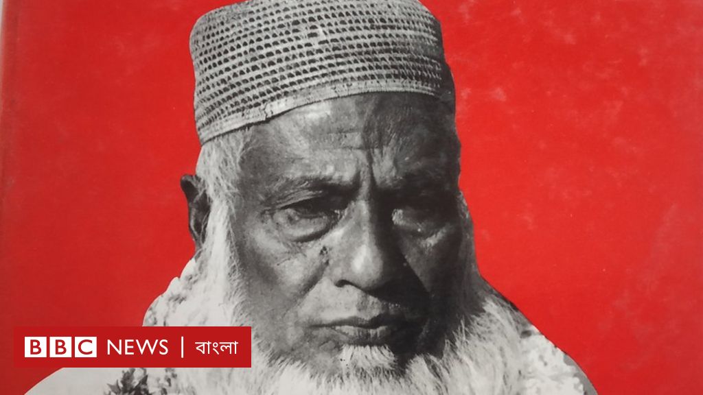
ছবির উৎস,মাওলানা ভাসানী স্মারক সংকলন বই
ছবির ক্যাপশান,
মাওলানা আব্দুল হামিদ খান ভাসানী
উনিশশো পঁচাত্তর সালের গোড়ার কথা। পাকিস্তানের কাছ থেকে স্বাধীনতা লাভের কয়েক বছরের মধ্যেই বাংলাদেশের পরিবেশ এবং প্রতিবেশের জন্য বড় এক অন্ধকার এসে হাজির হয়। বাংলাদেশের চাঁপাইনবাবগঞ্জ সীমান্ত থেকে ভারতের ১৮ কিলোমিটার ভেতরে গঙ্গা নদীর উপর একটি বাঁধ নির্মাণ করে ভারত। যেটি ফারাক্কা বাঁধ নামে পরিচিত।
এই বাঁধের প্রভাবে শুকনো মৌসুমে বাংলাদেশের দক্ষিণ-পশ্চিমাঞ্চলে পানির জন্য হাহাকার তৈরি হয়।
কলকাতা বন্দরের নাব্যতা রক্ষার যুক্তি দেখিয়ে ভারত এই ব্যারেজ নির্মাণ করে। ফলে বাংলাদেশে এর বিরূপ প্রভাব পড়ে। বাংলাদেশের দক্ষিণ-পশ্চিমাঞ্চলে এর ক্ষতিকর প্রভাব পড়ে।
উনিশশো ছিয়াত্তর সালের ১৬ই মে ফারাক্কা বাঁধের বিরুদ্ধে চাঁপাইনবাবগঞ্জ সীমান্তের দিকে একটি মিছিলের আয়োজন করেন বাংলাদেশের সুপরিচিত রাজনীতিবিদ মাওলানা আব্দুল হামিদ খান ভাসানী।
এই মিছিল ও সমাবেশ 'ফারাক্কা লংমার্চ' হিসেবে পরিচিত।
কেমন ছিল সেই 'ফারাক্কা লং মার্চ'?
মাওলানা ভাসানীর দীর্ঘ রাজনৈতিক জীবনে একটি উল্লেখযোগ্য ঘটনা হচ্ছে 'ফারাক্কা লং মার্চ' সংগঠিত করা।
মাওলানা আব্দুল হামিদ খান ভাসানী যখন ফারাক্কা লং মার্চের নেতৃত্ব দেন তখন তার বয়স ৯০ বছরের বেশি।

ছবির উৎস,BBC
উনিশশো ছিয়াত্তর সালের গোড়ার দিকে মাওলানা ভাসানী বার্ধক্যজনিত অসুস্থতার কারণে হাসপাতালে চিকিৎসাধীন ছিলেন।
ছিয়াত্তরের ১৮ই এপ্রিল হাসপাতাল থেকে ফেরার পর মাওলানা ভাসানী ঘোষণা দেন ভারত যদি বাংলাদেশকে পানির অধিকার থেকে বঞ্চিত করে তাহলে তিনি লংমার্চ করবেন।
তাঁর এই কর্মসূচী তখন অনেককে বেশ চমকে দিয়েছিল।
কারণ ৯০ বছরের একজন মানুষের ঘরেই থাকার কথা।
এজন্য ১৬ই মে রাজশাহী শহর থেকে লংমার্চ করার ঘোষণা দেন তিনি।
কর্মসূচী বাস্তবায়নের জন্য ১৯৭৬ সালের ২রা মে মাওলানা ভাসানীকে প্রধান করে ৩১ সদস্যবিশিষ্ট 'ফারাক্কা মিছিল পরিচালনা জাতীয় কমিটি' গঠিত হয়। এর পরে এই কমিটির সদস্য সংখ্যা আরো বৃদ্ধি পায়।
এই লংমার্চের আগে ভারতের তৎকালীন প্রধানমন্ত্রী ইন্দিরা গান্ধীর কাছে একটি চিঠি লিখেন আব্দুল হামিদ খান ভাসানী।
সে চিঠিতে মিসেস গান্ধির কাছে লংমার্চের কারণ বর্ণনা করেন ভাসানী।
সাংবাদিক এনায়েতউল্লাহ খান, আনোয়ার জাহিদ এবং সিরাজুল হোসেন খান এ চিঠি তৈরি করতে আব্দুল হামিদ খান ভাসানীকে সহায়তা করেন।
লংমার্চ সফল করার জন্য ১৯৭৬ সালের ২৮শে এপ্রিল মাওলানা ভাসানী এক বিবৃতিতে সকলের প্রতি আহবান জানান।

ছবির উৎস,RONNY SEN
ছবির ক্যাপশান,
১৯৭৫-এ যখন ফারাক্কাতে গঙ্গার ওপর বাঁধ নির্মাণের কাজ চলছে
জাতীয় কৃষক সমিতির আবু নোমান খান সে লংমার্চ সম্পর্কে বিস্তারিত বিবরণ তুলে ধরেছেন মজলুম জননেতা: মাওলানা ভাসানী স্মারক সংকলন' বইতে।
মি. খান লিখেছেন, লংমার্চের মিছিল রাজশাহী থেকে প্রেমতলী, প্রেমতলী থেকে চাঁপাইনবাবগঞ্জ, চাঁপাইনবাবগঞ্জ থেকে মনকষা এবং মনকষা থেকে শিবগঞ্জ পর্যন্ত ৬৪ মাইল অতিক্রম করবে।
মাওলানা ভাসানীর অনুসারীরা তাকে একজন রাজনীতিবিদের চেয়ে 'দার্শনিক' হিসেবেই বেশি বিবেচনা করতেন।
তার সমর্থকরা মনে করেন, ৪৫ বছর আগে ফারাক্কা বাঁধ সম্পর্কে মাওলানা ভাসানী যা অনুমান করেছিলেন, পরবর্তীতে সেটিই ঘটেছে।
বাংলাদেশের একজন লেখক আহমদ ছফাকে উদ্ধৃত করে ১৯৯৫ সালে দৈনিক ভোরের কাগজে ফরহাদ মজহার লিখেছেন, "বাংলাদেশের সর্বনাশ ঘটছে এটা তার চেয়ে স্পষ্ট করে কেউই বোঝে নাই।"
উনিশশো ছিয়াত্তর সালের ১৬ ই মে রাজশাহী শহর থেকে ফারাক্কা অভিমুখে মিছিল শুরু হয়। হাজার-হাজার মানুষ সমবেত হয় সেই মিছিল ও জনসভায়।
সে সময় বাংলাদেশ বেতার রাজশাহী কেন্দ্রের বার্তা বিভাগে কর্মরত ছিলেন হাসান মীর। তার বাড়িও রাজশাহীতে।
মি. মীর তখন লংমার্চের ঘটনা প্রত্যক্ষ করেছেন।
তিনি বিবিসি বাংলাকে বলেন, সাংগঠনিক তৎপরতা জোরদার করতে দুই-তিন দিন আগেই তিনি মাওলানা ভাসানী রাজশাহী এসে পৌঁছান।

ছবির উৎস,বিবিসি
ছবির ক্যাপশান,
ফারাক্কায় গঙ্গার ওপর বাঁধ
হাসান মীরের বর্ণনায়, "রাজশাহী শহরে তখন অচেনা মানুষের ভিড়। লংমার্চে অংশ নিতে দেশের বিভিন্ন এলাকা থেকে সর্বস্তরের মানুষ আসছে। রাস্তায় রাস্তায় লাউড স্পিকারে ঘোষণা হচ্ছে - ১৬ই মে রোববার মাদ্রাসা মাঠ থেকে লংমার্চ শুরু করবে। বাসা থেকে বেতার ভবনে যাওয়ার সময় দেখলাম পথঘাট লোকে লোকারণ্য। বিশাল মাদ্রাসা মাঠে ভীড় উপচে পড়ছে। "
সেই লংমার্চের খবর সংগ্রহ করতে রাজশাহী গিয়েছিলেন সাংবাদিক মোনাজাত উদ্দিন। তিনি তখন দৈনিক সংবাদের জন্য খবরা-খবর পাঠাতেন।
মোনাজাত উদ্দিনের স্মৃতিচারণমূলক লেখা 'পথ থেকে পথে' বইতে সেই লংমার্চের কিছু বিষয় বর্ণনা করেছেন।
মোনাজাত উদ্দিন লিখেছেন, "মিছিলের আগে মাদ্রাসা ময়দানে জনসভা। ভাসানী এলেন নীল গাড়িতে চেপে। জনসমুদ্র গর্জে উঠল। খুব অল্প সময়ের জন্য তিনি বক্তৃতা করলেন। বহু সাংবাদিক, বহু ফটোগ্রাফার।"
লংমার্চের ৬৪ কিলোমিটার যাত্রা ছিল বেশ কঠিন।
সবচেয়ে বড় আশংকা ছিল মাওলানা ভাসানীকে নিয়ে।
এমনিতেই তার বয়স ৯০ বছরের বেশি।
তার উপর কিছুদিন আগেই তিনি হাসপাতাল থেকে ছাড়া পেয়েছেন।
'মাওলানা ভাসানীর জীবনস্রোত' শিরোনামে একটি লেখায় সেই লং মার্চ সম্পর্কে বিস্তারিত বিবরণ দিয়েছেন জাতীয় কৃষক সমিতির সাবেক সপ্তর সম্পাদক আবু নোমান খান।
"মিছিলের শুরুতে ভাসানীসহ নেতৃবৃন্দ পুরোভাগে দাঁড়ান। মিছিলটি তিন মাইল দুরে রাজশাহী কোর্ট এলাকায় যেতে না যেতেই মুষলধারে বৃষ্টি নামে। তা সত্ত্বেও লক্ষ জনতার মিছিল এগিয়ে চলে। এগারো মাইল অতিক্রম করে প্রেমতলী পৌঁছে। তখন দুপুর দুটো," লিখেছেন আবু নোমান খান।
সেখানে কিছুক্ষণ বিশ্রাম নিয়ে বিকেল তিনটা নাগাদ লংমার্চ আবারো যাত্রা শুরু করে। এরপর প্রায় ২০ মাইল পথ অতিক্রম করে রাতে চাঁপাইনবাবগঞ্জ পৌঁছে মিছিলটি। রাতে সেখানেই তারা অবস্থান করেন। পরদিন সকাল আট ৮ টায় আবারো যাত্রা শুরু করে লংমার্চ। চাঁপাইনবাবগঞ্জ থেকে আরো ছয় মাইল পথ অতিক্রম করে কানসাট পৌঁছায়।
দুপুরের মধ্যে মিছিলটি পৌঁছে কানসাটে।
আবু নোমান খানের বর্ণনায়, "পথের দুধারে সারি বেঁধে দাঁড়িয়েছে হাজার-হাজার মানুষ - উদ্দেশ্য ফারাক্কা লং মার্চ-এর মিছিলকারীদের অভ্যর্থনা জানানো। মিছিলকারীদের পানি ও বিভিন্ন খাবার খাইয়েছেন তারা। "

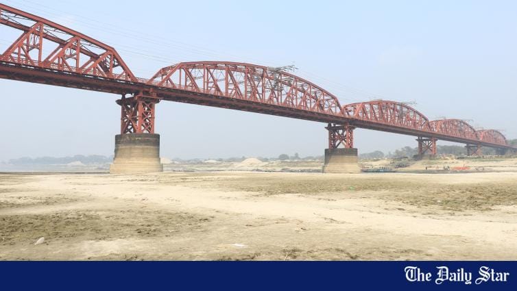
ছবির উৎস,বিবিসি বাংলা
ছবির ক্যাপশান,ফারাক্কা বাঁধের কারণে বাংলাদেশের কুষ্টিয়ার পদ্মা নদীর উপর হার্ডিঞ্জ ব্রিজের নিচ দিয়ে শুষ্ক মৌসুমে গাড়ি চলতে পারে।
বিকেল চারটার দিকে সেখানে জনসভায় বক্তব্য রাখেন মাওলানা ভাসানী। সে জনসভায় তিনি বলেন, ফারাক্কা সমস্যার সমাধানের জন্য ভারত যদি বাংলাদেশের মানুষের দাবি উপেক্ষা করে তাহলে ভারতীয় পণ্য বর্জনের আন্দোলন শুরু হবে।
হাসান মীর বলেন, "তিনি বাড়তি কোন ঝুঁকি নিতে চাননি বলে মিছিলকারীদের সীমান্তের কাছে যেতে নিষেধ করেন। আর এভাবেই মাওলানা ভাসানীর ঐতিহাসিক ফারাক্কা লংমার্চের সমাপ্তি ঘটে।"
ফারাক্কা লং মার্চের পর থেকে মাওলানা ভাসানীর শারীরিক অবস্থার অবনতি হতে থাকে। তখন থেকে মাওলানা ভাসানীর বেশিরভাগ দিন কেটেছে হাসপাতালে চিকিৎসার জন্য।
অগাস্ট মাসের মাঝামাঝি চিকিৎসার জন্য তাকে লন্ডন নিয়ে যাওয়া হয়।
উনিশশো ছিয়াত্তর সালের ১৭ ই নভেম্বর ঢাকা মেডিকেল কলেজ ও হাসপাতালে মাওলানা ভাসানীর মৃত্যু হয়।
ভারত কেন ফারাক্কা বাঁধ নির্মাণ করেছিল?
পলিমাটি জমে কলকাতা বন্দরের গভীরতা কমে যাওয়ায় কারণে বাংলাদেশের সীমান্ত থেকে ১৮ মাইল উজানে মনোহরপুরের কাছে ফারাক্কা বাঁধ নির্মাণ করে ভারত।
এই প্রকল্পের উদ্দেশ্য ছিল পশ্চিমবঙ্গের ভাগীরথী নদীতে পানি প্রবাহ বাড়ানো। সেজন্য গঙ্গা নদী থেকে বিপুল পরিমাণ পানি ভাগীরথী-হুগলী নদীতে নিয়ে যাওয়া হয়।
যাতে করে সেখানে জমে থাকা পলিমাটি পানিতে ভেসে যায় এবং কলকাতা বন্দরের গভীরতা বজায় থাকে।
উনিশশো চুয়াত্তর সালে বাংলাদেশ ও ভারতের প্রধানমন্ত্রী এক বৈঠকে একমত হন যে শুষ্ক মৌসুমে পানি ভাগাভাগির বিষয়ে দুই দেশ একটি চুক্তিতে না পৌঁছানো পর্যন্ত ফারাক্কা বাঁধ চালু করা হবে না।
কিন্তু ভারত সে কথা রাখেনি। উনিশশো পঁচাত্তর সালের শুরুর দিকে ভারত বাংলাদেশকে জানায় যে ফারাক্কা বাঁধের ফিডার ক্যানেল পরীক্ষা করা প্রয়োজন।
পঁচাত্তরের সালের ২১ শে এপ্রিল থেকে মাত্র ১০ দিনের জন্য এটি পরীক্ষার কথা বলেছিল ভারত। এতে বাংলাদেশ রাজী হয়। কিন্তু এরপরেও ভারত একতরফাভাবে গঙ্গানদীর গতি পরিবর্তন করে।
শেষ পর্যন্ত ১৯৯৬ সালে ২১ বছর পর আওয়ামী লীগ সরকার ক্ষমতায় ফিরে এলে গঙ্গার পানি বণ্টন চুক্তি সাক্ষরিত হয়।
এর আগে বিভিন্ন সরকারের সময় বিষয়টি জাতিসংঘসহ বিভিন্ন ফোরামে উত্থাপন করে ভারতের উপর আন্তর্জাতিক চাপ সৃষ্টির চেষ্টা করা হয়। কিন্তু তাতে খুব একটা লাভ হয়নি।
ছিয়ানব্বই সালে পানি বণ্টন চুক্তি সাক্ষরের পরেও অভিযোগ রয়েছে, শুষ্ক মওসুমে ভারত চুক্তি অনুযায়ী বাংলাদেশকে পানি দেয় না।