☕ Support Us
[🇧🇩] - India's Water Terrorism Against Bangladesh | Page 24 | PKDefense

[🇧🇩] India's Water Terrorism Against Bangladesh

Reply (Scroll)
Press space to scroll through posts
G Bangladesh Defense
[🇧🇩] India's Water Terrorism Against Bangladesh
239
8K
More threads by Saif


Feni faces flash flood again as India opens barrage
Nazmul Haque Shamim . Feni 22 July, 2025, 00:13

1753143962527.png

A corrugated iron-roofed house is washed away by flash flood in Feni’s Muhuri basin Monday morning. Thousands of residents are caught off guard as the trans-boundary river swell nearly 11 feet in just three hours despite no prior flood forecast. | New Age photo

Thousands of people living along the Muhuri basin in Feni district witnessed something strange waking up on Monday morning when the trans-boundary river swelled by nearly 11 feet in just three hours by 9:00am.

Bangladesh’s Flood Forecasting and Warning Centre, in its special bulletin issued at 8:25pm on Sunday with the warning of a flash flood along Teesta basin in northern districts did not had any warning against the disaster impending on the south-eastern Bangladesh.

It rained moderate to heavy in the river’s catchment spreading between India’s Tripura and Bangladesh in the preceding 24 hours before the river started rising, not enough to cause such a massive change in its water level overnight.

‘There was not enough rain to have unleashed such a large volume of water,’ said Sarder Udoy Raihan, executive engineer at the FFWC.

Forecasters at the FFWC could only watch as the Muhuri swelled another 119cm between 9:00am and 3:00pm on Monday, flowing just 56cm below the danger level, setting off a flash flood warning for today.

Mostofa Kamal Palash, an independent weather forecaster based in Canada, pointed out as a source of the water India arbitrarily opening its Kalashi barrage.

The reason could be, he wrote on a Facebook post, India emptying the barrage’s storage to tackle the next wet spell likely in just three days.

‘The Joint Rivers Commission, Bangladesh can look into the matter,’ Palash wrote.

The sudden release of water was the last thing Bangladesh expected with many embankments in Parshuram and Fulgazi barely standing with holes dug in them in the latest spell of flash flood early this month. Huge volumes of water gushed through the breaches to engulf low lying areas, including farmland.

‘We did not have a respite for even 10 days. Yet another flash flood hits us,’ said Sajeda Akter, a resident of Sreepur of Fulgazi.

Originating in the southern part of Gomati district in Tripura of India, the Muhuri River, with contribution from tributaries in the Shahebmura hill, flows west to enter Bangladesh through Parshuram. The river merges with the Feni River flowing 35km downstream. The Muhuri and Feni rivers have a combined catchment area of 2,413 square kilometres, which makes them two of the smallest rivers.

Sudden releases of massive volumes of water on the narrow catchment of the Muhuri could mean serious devastation downstream.

India opening its barrages built on many transboundary rivers has been the bone of contention for decades. India almost routinely opens the Gajoldoba barrage without warning Bangladesh whenever the upper riparian nation chooses to do so.

The Teesta rapidly swelled on Sunday after India opened floodgates at the Gajoldoba barrage on Saturday afternoon.

The FFWC forecasters said that they did not have any information shared by India on the Kalashi barrage, which is about 50km upstream from the Indian border with Bangladesh.

Without having information of rain in the catchment of the Muhuri and its water level data, predicting flash flood events is an almost impossible task, the forecasters said.

The FFWC had rainfall info on only one station at Belonia in the river’s basin from India. Belonia received 41.8mm of rain in the 24 hours ending at 9:00am on Monday.

Parshuram in Bangladesh, on the other hand, experienced 60.5 mm of rain over the same reporting cycle, the FFWC said.

The FFWC warned that the Feni district was approaching yet another flash flood with a low pressure likely to form over the Bay of Bengal on July 24, potentially bringing up to 350mm of rain over three days in Chattogram and its adjacent areas in upstream Tripura.

Intermittent rainfall caused waterlogging and inundation in Tripura since the first week of July.

Feni suffered a flash flood in the second week of the month when the Muhuri rose about 20 feet above its danger mark in the 24 hours until 9:00am on July 9.

But the early July event occurred amidst record rain. In the 24 hours until 6:00pm on July 9, the Bangladesh Meteorological Department recorded 399mm rain in Feni, the second highest volume of rain the weather station recorded ever since it was established in 1973.

Between July 7 and 9, Feni recorded 584mm rainfall, 80 per cent of the average normal rain for the entire month.

In the 24 hours until 9:00am on Monday, the Teesta swelled by up to 29cm, the FFWC said, flowing 21cm below the danger mark at Kaunia in Rangpur.​
 

India’s arbitrary decision on cross-border river unacceptable
24 July, 2025, 00:00

THOUSANDS of people living in the Muhuri basin in Feni recovering from socio-economic losses of the flash flood earlier in July are now faced with similar uncertainty again as the transboundary river swelled by 11 feet in three hours with no warning on June 20. It rained moderately to heavily on the catchment area spreading between India’s Tripura and Bangladesh in the preceding 24 hours before the river started rising, which is not enough to cause such an overnight change in river height. The Bangladesh Flood Forecasting and Warning Centre warned of a flash flood in the Teesta basin in the north but made no mention of the impending disaster in the south-east. Meanwhile, independent weather forecasters point out that India was clearing water from the barrage storage to tackle the impending wet spell and arbitrarily opened the Kalashi barrage. The government should immediately take up the issue with the Joint River Commission and other diplomatic channels.

India opening its barrages built on many transboundary rivers has been the bone of contention for decades. India almost routinely opens the Gajaldoba barrage without warning. The flood forecasting authorities say that they had no information shared by India on the Kalashi barrage, which is about 50km upstream the border. Without having information on rain in the catchment of the Muhuri and its water level data, forecasting flash flood is an almost impossible task. Another flash flood is approaching Feni, with a low likely to form over the Bay of Bengal on July 24, potentially bringing up to 350 millimetres of rain over three days in Chattogram and adjacent areas in upstream Tripura. An unequal access to water in transboundary rivers has also caused the death of many rivers in the north. In the name of sharing, India holds water during the dry season that severely affects farming in the north and opens the gates during the monsoon season to manage flood water in West Bengal. In March, the Joint River Commission agreed on a collaborative approach to address important issues, including information exchange on flood forecasting and water sharing. The flash flood situation in Feni suggests that such promises remain rhetorical as India continues to make arbitrary decisions on river-water sharing.

The government should, therefore, immediately and strongly raise its concern with India that its arbitrary decisions are not only a deviation from the river water sharing decisions but also a violation of international practice and protocols on transboundary river management. The government should also ensure that emergency relief and shelter support are readily available for the affected people in Feni.​
 

Will go to int'l court or UN to secure our fair share of water: Tarique
1754876621768.png


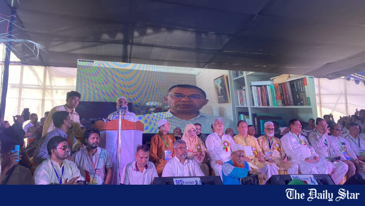
Rajshahi city BNP held its biennial council today in the city's Pathanpara area, with Acting Chairman Tarique Rahman joining virtually as chief guest.

He pledged to rebuild institutions including education, judiciary, law enforcement, economy, and health, if elected.

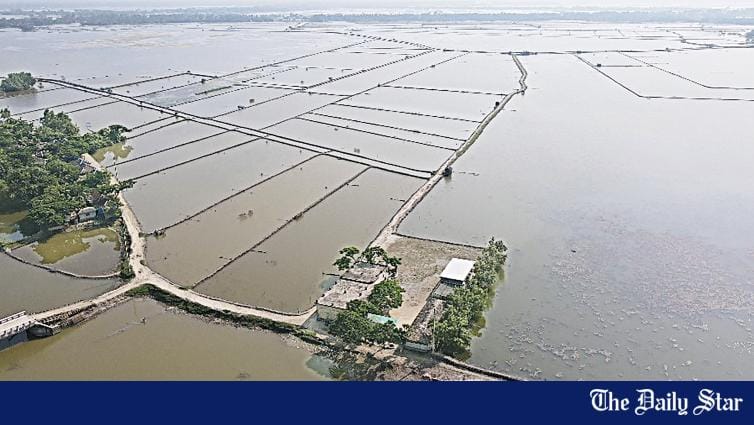
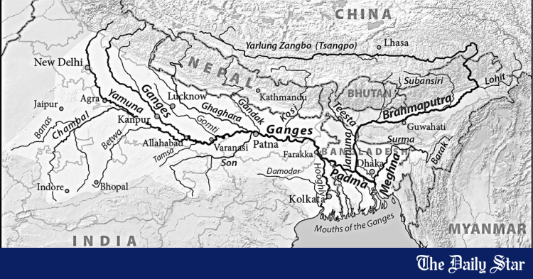
In his speech, Tarique warned that the Padma River, once a lifeline for Rajshahi's fertile lands, was drying up due to the Farakka Barrage, turning green fields into arid land.

"Bangladesh is an agriculture-based country. In Rajshahi city, we have seen how the Padma River is drying up. If necessary, we will go to the international court or the United Nations to secure our fair share of water," he said.

He also stressed the need to excavate canals to retain water for farmers and public use in case of future disputes.

Tarique highlighted BNP's 31-point agenda for "repairing the state," first presented nearly two years ago.

He said many of the reforms now under discussion by the interim government's reform commission were already proposed by the BNP.

"Our next step is to implement these 31 points by earning the trust and confidence of the people," he added.

He noted that the interim government was moving toward a national election before Ramadan, which he called the "first step" toward restoring political rights.

At the council, Tarique said BNP would assign duties to strengthen the party, promote its policies, and prepare for governance.

The council was presided over by Rajshahi city BNP Convener Ershad Ali, while Member Secretary Mamun-ur-Rashid conducted the programme.​
 
Why is this joint military exercise by the Indian armed forces near Farakka Barrage? Do the Indian armed forces expect any attempt by the Bangladesh armed forces to knock down Farakka Barrage?

 
Last edited:

India’s arbitrary decision on cross-border river unacceptable
24 July, 2025, 00:00

THOUSANDS of people living in the Muhuri basin in Feni recovering from socio-economic losses of the flash flood earlier in July are now faced with similar uncertainty again as the transboundary river swelled by 11 feet in three hours with no warning on June 20. It rained moderately to heavily on the catchment area spreading between India’s Tripura and Bangladesh in the preceding 24 hours before the river started rising, which is not enough to cause such an overnight change in river height. The Bangladesh Flood Forecasting and Warning Centre warned of a flash flood in the Teesta basin in the north but made no mention of the impending disaster in the south-east. Meanwhile, independent weather forecasters point out that India was clearing water from the barrage storage to tackle the impending wet spell and arbitrarily opened the Kalashi barrage. The government should immediately take up the issue with the Joint River Commission and other diplomatic channels.

India opening its barrages built on many transboundary rivers has been the bone of contention for decades. India almost routinely opens the Gajaldoba barrage without warning. The flood forecasting authorities say that they had no information shared by India on the Kalashi barrage, which is about 50km upstream the border. Without having information on rain in the catchment of the Muhuri and its water level data, forecasting flash flood is an almost impossible task. Another flash flood is approaching Feni, with a low likely to form over the Bay of Bengal on July 24, potentially bringing up to 350 millimetres of rain over three days in Chattogram and adjacent areas in upstream Tripura. An unequal access to water in transboundary rivers has also caused the death of many rivers in the north. In the name of sharing, India holds water during the dry season that severely affects farming in the north and opens the gates during the monsoon season to manage flood water in West Bengal. In March, the Joint River Commission agreed on a collaborative approach to address important issues, including information exchange on flood forecasting and water sharing. The flash flood situation in Feni suggests that such promises remain rhetorical as India continues to make arbitrary decisions on river-water sharing.

The government should, therefore, immediately and strongly raise its concern with India that its arbitrary decisions are not only a deviation from the river water sharing decisions but also a violation of international practice and protocols on transboundary river management. The government should also ensure that emergency relief and shelter support are readily available for the affected people in Feni.​

"Raising concern" with Indian authorities will do jack squat. Raising tariff is what we need to do. On Indian exports to Bangladesh. Let it be a foregone warning, then - if violated, take the promised action.
 
Why is this joint military exercise by the Indian armed forces near Farakka Barrage? Do the Indian armed forces expect any attempt by the Bangladesh armed forces to knock down Farakka Barrage?


Much ado about nothing. Feku and his stupid vote-getting tactics.

Looking for ghosts and goblins from across the border.
 

Teesta project: Bangladesh seeks Tk 67 billion Chinese loan

The Teesta project is geopolitically sensitive. The United States, India, and 12 other countries are currently trying to include Bangladesh into the Indo-Pacific Economic Framework (IPEF). On the other hand, China wants Bangladesh to align with its strategic interests, and is now seeking Bangladesh’s participation in a forum alongside Pakistan.

Arifur Rahman Dhaka
Published: 19 Aug 2025, 08: 50

1755649095150.png

Dried Teesta river File photo

The interim government has moved to implement the Teesta Mega Project with Chinese loans and a letter has already been sent to China requesting funding of Tk 67 billion (6,700 crore).

Following chief adviser Professor Muhammad Yunus' visit to China in March, momentum around the project has picked up.

According to policymakers, a financial agreement between the two countries could be signed before the end of this year.

The full name of the project is "Comprehensive Management and Restoration of Teesta River Project", commonly known as the Teesta Mega Project.

Both China and India have shown interest in the project at different times.

India's former foreign secretary Vinay Kwatra expressed India's interest in investing in the Teesta project during his visit to Bangladesh in early May 2024. The Awami League government, which was ousted in a mass uprising in August, had also wanted India to finance the project.

During a press conference at Gonobhaban on 14 July 2024, former prime minister Sheikh Hasina said regarding the China visit, "China is ready, but I want India to do it. If India undertakes this project, they will continue to provide whatever is needed for it. That’s the plain truth—no sugarcoating."


Just 22 days after that press conference, the Awami League government fell in a student-led mass uprising, and Sheikh Hasina fled to India.

On 8 August 2024, an interim government was formed under the leadership of Professor Muhammad Yunus. The relationship between this new government and India remains tense.

Amid such circumstances, the current administration is aiming to implement the Teesta project with Chinese funding. In March, chief adviser Yunus visited China, and since then, relevant ministries and agencies have begun working to advance the project.

On 26 May, the water resources ministry sent a letter to the planning commission, mentioning Chinese loan support for the Teesta project. In the second week of July, the Economic Relations Division (ERD) also sent a letter to the Chinese embassy.

1755649135719.png

Female farmers are working in a potato field on Teesta River bed as the river has dried up in Kaonia upazila of Rangpur. Photo: Moinul Islam, Rangpur

Speaking about this, on 5 July, planning adviser Wahiduddin Mahmud told Prothom Alo that the incumbent government is interested in implementing the Teesta project with Chinese loans, and China also wants to proceed.

He stated that both sides are moving forward with mutual consent. As the project design has not yet been finalised, the primary task now is to complete the design. Once that is done, the Development Project Proposal (DPP) and the financial agreement process can proceed simultaneously.

According to the project documents, the first phase of the Teesta project is estimated to cost $750 million, which is equivalent to Tk 91.5 billion (calculated at Tk 122 per dollar). Of this amount, $550 million (around Tk 67 billion) has been requested as a loan from China. The remaining funds will come from the government’s exchequer. Work on the project is scheduled to begin in 2026, with a target to complete it in 2029.

The letter from the water resources ministry states that the feasibility study for the project has already been completed and expert opinions will be sought on the matter.

The Teesta project is extremely important for Bangladesh for three main reasons: to control flooding in the Teesta basin during the monsoon; to reduce riverbank erosion before and after the monsoon; and to increase water flow in the river during the dry season----Ainun Nishat, Water and climate change expert.

The ministry also attached the feasibility report with its letter. The study was conducted by Power Construction Corporation of China (PowerChina), a state-owned Chinese company that specialises in planning, constructing, financing, and investing in infrastructure projects.

After reviewing the letter and the feasibility report, the planning commission sent a separate letter to the Economic Relations Division (ERD) on 1 July, stating that the preliminary cost estimate for the project has been approved by the planning adviser, subject to a reasonable cost justification. The commission also said it supports seeking a loan from China for the project. The ERD is the government agency responsible for coordinating foreign loans and aid.

ERD secretary Shahriar Kader Siddiky told Prothom Alo that a letter has already been sent to China requesting a loan for the Teesta project and that the project formulation process is underway.

According to a source at the ERD, once China receives the loan request, the Chinese government will draft and send a preliminary agreement.

Meanwhile, the water resources ministry will finalise the project proposal. These two processes will run in parallel.

Desertification has been going on as the Teesta basin lacks water flow. But the area is sensitive as it is near the Siliguri corridor. India does not want the presence of China in the area. India will oppose if steps are taken to implement the project with funding from China-----Maj. Gen. (retd) ANM Muniruzzaman, BIPSS President.

When asked about China’s role in financing the Teesta project, Chinese ambassador to Bangladesh Yao Wen told the media at the National Press Club on 29 July that China is interested in working with Bangladesh on the project.

He, however, noted that they have not yet received any formal request from the Bangladeshi side.

Drought in summer, erosion in monsoon

The Teesta is a transboundary river shared by Bangladesh and India. It flows through India’s Sikkim and West Bengal states before entering Bangladesh. India has constructed dams on its side and withdraws water from the river. Due to this water withdrawal and riverbank erosion, the livelihoods and settlements of people living along the Teesta in Bangladesh are under threat.

Experts say that the lack of water in the Teesta during critical periods has hindered poverty reduction in the northern districts of Gaibandha, Nilphamari, Lalmonirhat, Rangpur, Kurigram, and Dinajpur. A poverty map published by the Bangladesh Bureau of Statistics (BBS) in January shows these northern districts as having relatively higher poverty rates.

According to data from the Bangladesh Water Development Board (BWDB), the Teesta River stretches 115 kilometres within Bangladesh. Of this, 45 kilometres are prone to erosion, with conditions being particularly severe along 20 kilometers. Continuous erosion occurs in the Kurigram district, particularly in Rajarhat, Ulipur, and Chilmari upazilas.

Erosion also takes place in Lalmonirhat, Nilphamari, Rangpur, and Gaibandha. So far, no effective measures have been implemented to prevent this erosion.

Syeda Rizwana Hasan, Adviser on Water Resources, said in a written statement to Prothom Alo on 30 July that the Teesta is an international river. As a downstream country, and in the absence of an agreement over many years, Bangladesh has little control over its flow and is not receiving its fair share of water.

She further said that the residents whose livelihood and lives depend on the river are long plagued by erosion, the threat of flooding and the shortage of irrigation water, have for years been demanding the implementation of the Teesta Mega Plan and related projects, which would ensure a sustainable flow of water in the river and protect people from sudden floods and severe erosion.

“Together with the people living along the Teesta, and with assistance from China, we are working towards that very goal,” she added.

To be continued.............................
 
What the project includes

The Teesta project formally began in 2016 with the launch of a feasibility study. An analysis of project documents shows that the river will be dredged over 102 kilometres, increasing its depth by approximately 10 metres. This is expected to prevent widespread flooding in nearby populated areas during the monsoon.

It further said that around 171 square kilometers of land will be reclaimed and developed. In addition, 203 kilometers of embankments will be constructed. The project also includes dredging of chars, developing satellite towns on both banks of the river, and reclaiming agricultural land by removing sand deposits.

According to the Bangladesh Water Development Board (BWDB), the construction of groynes (river training structures) and riverbank protection measures will help prevent erosion. The building and repair of embankments will reduce flood risk. Dredging will help restore the river’s natural flow and ensure navigability of its tributaries.

To maintain law and order, the plan includes establishing police stations, Coast Guard outposts, and army camps along both banks. Additionally, the BWDB states that there are plans to develop marine drives, hotels, motels, restaurants, a tourism city, planned urban centres, and ports on both sides of the embankments, similar to a seaside resort.

On 28 July, water and climate change expert Ainun Nishat told Prothom Alo that the Teesta project is extremely important for Bangladesh for three main reasons: to control flooding in the Teesta basin during the monsoon; to reduce riverbank erosion before and after the monsoon; and to increase water flow in the river during the dry season.

“This is a technically complex project and should have included consultation meetings with stakeholders. But as far as I know, that hasn't happened. At least, I was not invited—perhaps they didn’t consider me competent,” he said.

Regarding seeking loans from China, Ainun Nishat added, “A huge amount of money is needed to implement the Teesta Mega project. The government will have to consider all the sides before taking loans from whoever would be interested to invest in the project. China will come not only with money but with technology as well.”

However, Ainun Nishat believes that no matter what technical work China does on the Teesta project, the river’s dry season flow will not increase unless India releases water. This has to be resolved through discussion with India.

Teesta deal remains elusive

The dispute between Bangladesh and India over Teesta water is long-standing. In 1983, the two countries signed a temporary agreement stating that India would receive 39 per cent of the Teesta’s water and Bangladesh 36 per cent, with the rest unallocated. However, a permanent agreement was never reached.

1755649604364.png


In 2011, during then Indian prime minister Manmohan Singh’s visit to Bangladesh, a Teesta water-sharing agreement was expected to be signed. A draft was also prepared, but the deal was halted at the last minute due to objections from West Bengal chief minister Mamata Banerjee. Although Bangladesh has repeatedly raised the issue with India, the agreement has not moved forward since.

The Teesta project is geopolitically sensitive. The United States, India, and 12 other countries are currently trying to include Bangladesh into the Indo-Pacific Economic Framework (IPEF). On the other hand, China wants Bangladesh to align with its strategic interests, and is now seeking Bangladesh’s participation in a forum alongside Pakistan.

In this context, who finances a “strategic” project like Teesta has become highly significant. However, several senior officials at the foreign ministry told Prothom Alo that they prefer a “go-slow” approach regarding taking Chinese loans for the Teesta project.

Former Bangladeshi ambassador to the United States, M. Humayun Kabir, told Prothom Alo that although Bangladesh and India were supposed to sign a water-sharing agreement in 2011, it never materialised.

As a result, he said, Bangladesh currently has no viable alternative, and that’s why the government is leaning toward China for implementing the Teesta project. However, he emphasised that national interest must remain the top priority.

1755649625236.png

Thousands of demonstrators step into the Teesta River water near the Teesta Rail Bridge in Lalmonirhat to protest against the “water aggression” of India against Bangladesh on 18 February 2025. Prothom Alo

Humayun Kabir also noted that a broader regional initiative on water management is becoming increasingly necessary, as India has recently suspended its Indus River water treaty with Pakistan, and China is constructing a massive dam on the Brahmaputra River.

Given this, he pointed out, a framework for mutual cooperation to ensure uninterrupted water flow is essential. If Bangladesh wishes, it could take the initiative to lead such a regional water management effort.

Speaking about the situation, Bangladesh Institute of Peace And Security Studies (BIPSS) President Maj. Gen. (retd) ANM Muniruzzaman told Prothom Alo that the Teesta project is essential for Bangladesh.

He further said desertification has been going on as the Teesta basin lacks water flow. But the area is sensitive as it is near the Siliguri corridor. India does not want presence of China in the area. India will oppose if steps are taken to implement the project with funding from China.

According to him, it would be better if the interim government does not make any decision regarding such a sensitive matter. An elected government should go ahead with such projects.​
 

Salinity puts lives, livelihoods at risk in the South

1763776481972.webp

Shrimp enclosures have replaced farmland in Dakkhin Kalikapur village of Khulna’s Koyra upazila. Photo: Habibur Rahman

The struggle to cope with rising salinity, depleting sweet water, and diminishing livelihoods continues on the frontlines of climate change in Bangladesh's rural south west all the while negotiators struggle for a fairer agreement at the UN summit in Brazil's Belem. The Daily Star's Wasim Bin Habib visited towns and villages, tea stalls and paddy fields in Khulna and Satkhira in mid-October, speaking with homemakers, farmers, fishers, and experts to find out what climate change actually means to people on the ground. This is the first of a five-part series.

As dawn breaks over the muddy banks of the Kholpetua river in Satkhira's Shyamnagar upazila, a pale orange glow spreads across the horizon, lighting up mangrove trees and fishing boats at anchor.

Mohammad Gafur, a small trader in Burigoalini union, walks slowly along the embankment, his worn sandals sinking into the damp, uneven earth. The morning breeze brushes against his face as he pauses, gazing at what was once his father's farmland. Life, he recalls, used to be simple.

"We would drink straight from tubewells, and two rice harvests a year were certain," says the 60-year-old man, his face bearing the marks of years of hardship.

Then, changes came quietly. Shrimp farms replaced paddy fields, causing salt to seep into groundwater.

"This is no longer the land our forefathers knew," says Gafur. Around him, the silence of the morning is broken by the lapping of the Kholpetua, which carries the sting of saline intrusion.

Across the southwestern districts of Satkhira and Khulna, millions like Gafur are witnessing the gradual intrusion of salinity into their lives. The concentration of salt in water and soil has become one of the gravest environmental challenges for Bangladesh's 19 coastal districts, threatening livelihoods and habitability of the region.

Once confined to the fringes of tidal rivers, salinity is now steadily seeping deep into soil and groundwater due to reduced upstream flow, rising sea levels, cyclones and reckless changes in land use.

Fields that once yielded rice and vegetables have lost productivity and been converted into shrimp enclosures, while freshwater sources are turning brackish, making daily life a struggle for millions.

Data from the Soil Resources Development Institute (SRDI) paints a stark picture of this relentless march of salinity.
  • Salinity-hit land increased from 83.3m hectares in 1973 to 105.6m in 2009​
  • 62% of coastal land affected by varying degrees of salinity​
  • Shrimp farms replaced paddy fields, causing salt to seep into groundwater​
  • Excessive extraction of groundwater led to depletion of freshwater​

In 1973, salinity-affected land stood at 83.3 million hectares, which rose to 102 million in 2000. It reached 105.6 million by 2009 -- a nearly 26 percent increase over 35 years. Another 35,440 hectares of land were affected by various degrees of salinity from 2000 to 2009.

The trend shows no sign of slowing, as salinity is encroaching beyond the coastal belt into fertile inland regions, reshaping both landscapes and livelihoods.

Around 62 percent of coastal land is now affected by varying degrees of salinity, according to a government task force report published in January this year.

"Our recent test results of soil samples from different rivers and areas across the Khulna region show a steady rise in salinity," said Amarendranath Biswas, principal scientific officer at the SRDI's Batiaghata office in Khulna.

He explained that the rise becomes most evident between March and June, when soil salinity crosses 4 deciSiemens per metre (dS/m) -- the level at which crop yields begin to decline.

"The tolerable limit is around 2 dS/m, but in some areas, we found levels ranging from 12 dS/m to 16 dS/m.

According to a World Bank study, climate change is likely to significantly increase salinity in rivers and groundwater by 2050, deepening shortages of freshwater across Bangladesh's southwest coastal belt.

GRADUAL INVASION OF SALT

The salinity problem stems from a convergence of natural and human-made factors -- choices made in the name of development, and the unintended consequences that followed.

In the 1960s, the "Coastal Embankment Project" was launched to protect low-lying areas close to the Bay of Bengal from tidal floods and saline intrusion. Vast tracts of land were reclaimed for agriculture and human settlement. People started growing rice and vegetables across large areas, using groundwater.

But excessive extraction of groundwater led to the depletion of freshwater in shallow aquifers.

By blocking natural tidal flows, the embankments disrupted the intricate drainage and sediment systems of the delta. Over time, sedimentation raised riverbeds, reducing drainage capacity and causing saline water to stagnate within polders during high tides. Instead of preventing salinity, many embanked areas became prone to waterlogging and soil degradation.

Upstream diversion of freshwater, especially through the Farakka Barrage opened in 1975 and other control structures, reduced freshwater flow into Bangladesh's southwestern rivers during the dry season, weakening the natural flushing mechanism that once pushed saltwater back towards the sea.

Climate change and sea-level rise are amplifying the threat, while cyclones and tidal surges push saline water farther inland.

Sea-level rise may displace nine lakh people in southern Bangladesh by 2050, jeopardising their livelihoods and homes, according to a report by the International Centre for Climate Change and Development published last year.

By the end of the century, the situation is likely to worsen, as rising seas are projected to submerge between 12 and 18 percent of the coastal region, it said.

Sharmind Neelorme, an expert on climate change, explained that tidal movements and wind currents push seawater inland during high tide, leaving salt on land. Normally, river currents and rains carry the deposited salt back into the Bay of Bengal.

"But global warming has intensified tidal surges, making them stronger and higher. As water levels rise, the surges spread farther inland, flooding areas that were previously unaffected," said Neelorme, a professor of economics at Jahangirnagar University.

SHRIMP FARMING PARADOX

The unchecked and unregulated expansion of shrimp farming that began in the 1980s has deepened the crisis, according to experts and locals.

Over the last few decades, vast tracts of paddy fields have been turned into shrimp enclosures -- locally called ghers -- for which farmers illegally cut through embankments to bring in saline water.

Such breaches in coastal embankments to fill ponds have allowed salt to travel farther inland, contaminating both soil and groundwater. Now, many people in the area are trying their luck with crab farming, using a similar method.

While the shift from agriculture to aquaculture brought fast money for some, it systematically altered the landscape and destroyed the freshwater ecosystems that had sustained traditional farming for centuries.

"Shrimp has brought money, but we've lost the soil's fertility, crops, and the sweetness of water. We're trapped," said former rice farmer Liaqat Ali, who is now struggling with a small shrimp enclosure in Burigoalini.

The production of shrimp, locally known as "white gold", has been in decline because of various aquaculture diseases. "We cannot go back to agriculture either, as the land here is no longer suitable for growing rice or any other crop," he said.

Regarding unregulated shrimp farming, Neelorme said, "When shrimp exports began in the 1980s, we never questioned why we were deliberately allowing saline water into our lands."

While export volumes have remained static, many marginal farmers have since lost their land to excessive salinity, she added.

Shrimp farming also changed the social fabric, concentrating wealth in the hands of a few landowners. Many small farmers and day labourers are now forced to survive on meagre wages, often under precarious and exploitative conditions.

"I used to grow Aman and Boro. Now I sort shrimp for Tk 300 a day… It's not a life anyone wants," said 53-year-old Mohammad Rejaul from Shyamnagar in Satkhira.

HUMAN COST

Rising salinity is now impacting everyday life. In many coastal villages, access to safe drinking water has become a daily ordeal. Tubewells pump out saline water, and women and girls must travel miles to fetch potable water from distant sources.

Skin diseases and waterborne illnesses are common due to prolonged exposure to saline water. Pregnant women face additional health risks, as the consumption of water with high salinity is linked to various health complications.

"While we collect potable water from faraway places, we have no alternative but to use the brackish pond water and saline water from tubewells for bathing, household chores and even cooking. The water damages our skin and leaves rashes that don't heal easily," said Rahima Khatun, a homemaker from Burigoalini.

In many households, income loss and water scarcity have pushed families into debt. Young men migrate to towns for work, leaving behind elderly parents, while women manage homes under hostile conditions.

As the dry season approaches, villagers in Satkhira and Khulna brace for another year of hardship. Women and girls will walk farther for water and farmers will gamble on uncertain harvests.

While weighing the costs, the people in the area remain resilient.

"We've lived here for generations fighting salt… If we get support, we'll fight back. But we can't do it alone," said Gafur.

[Our Khulna and Satkhira correspondents also contributed to the report]​
 

Members Online

Latest Posts

Latest Posts