[đŸ‡§đŸ‡©] Smart Flood Management for Bangladesh

  • Thread starter Thread starter Saif
  • Start date Start date
  • Replies Replies 44
  • Views Views 612
[đŸ‡§đŸ‡©] Smart Flood Management for Bangladesh
44
612
More threads by Saif

G Bangladesh Defense Forum

Saif

Senior Member
Jan 24, 2024
10,486
5,860
Origin

Residence

Axis Group

We must reduce our vulnerability to flood
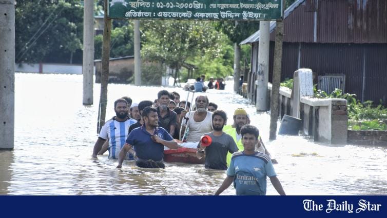
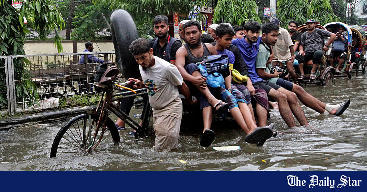
Signs of resilience as severe flooding tests the nation

1724542593689.png

VISUAL: STAR

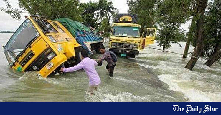
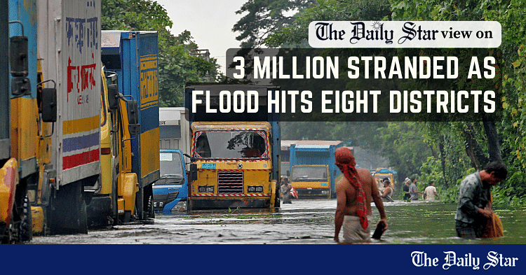
The ongoing flood has once again highlighted the need for taking decisive actions to reduce our vulnerability to seasonal disasters. With climate change, our internal river management problems, and unresolved external issues with India exposing the fault lines for a country otherwise known for its disaster preparedness, the time has come for Bangladesh to approach this issue with the urgency that it deserves, especially considering the huge human and economic tolls. Reports coming from the ground are quite alarming: at least 15 lives lost and 48 lakh people affected in 11 districts as of Friday afternoon. Earlier, it was reported that over 887,000 families were marooned, with about 77 upazilas under water.

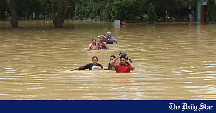
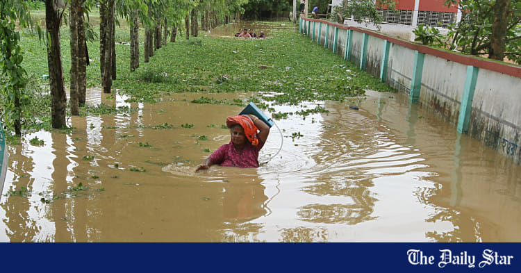
The Feni and Cumilla situations remain as dire as before. In Cumilla, the collapse of an embankment on the Gumti River has left about 500,000 people stranded. People in other districts including Khagrachhari, Noakhali, Chattogram, Moulvibazar, Habiganj, Brahmanbaria, Sylhet, Lakshmipur and Cox's Bazar are also facing severe challenges. Despite all that, one reason to be hopeful about the direction in which Bangladesh is going at present is the spontaneous response of people to help with the aid and rescue efforts. Besides government initiatives in collaboration with the military, coast guard, and emergency services, private platforms and student volunteers have turned up in large numbers, reflecting the nation's solidarity at this moment of crisis. They are working despite considerable hurdles, including lack of electricity and mobile network and impassable roads, with a large number of people in flood-hit districts still disconnected.

That said, we must turn our focus to what's causing the severe flooding and how to reduce our vulnerabilities. Since August 19, the country's eastern region has experienced extremely heavy rainfall for three consecutive days, the highest in 53 years. This, combined with upstream flooding and the narrowing of water drainage paths in Bangladesh, has rapidly deteriorated the situation. This was compounded by inadequate early warning systems. A critical factor in this is the lack of warning about upstream water flows from the Indian authorities, which experts say has exacerbated the situation. Effective cross-border water management and better coordination with India are essential to improve our response. The Joint River Commission and the National River Conservation Commission (NRCC) have a huge role to play in this regard, which they must do.

In addition to cross-border river issues, encroachments and blockages in Bangladesh's river systems are another major concern. The estimates given by the NRCC about river encroachers show how the latter have encroached river land across the country, exacerbating the impact of flooding. Going forward, we must bring these encroachers to book and improve water flow in our rivers. A comprehensive approach to flood management is necessary. This includes restoring natural river channels, addressing encroachments, and strengthening regional cooperation and the effectiveness of relevant institutions to prevent future disasters. Given the repetitive nature of flash floods caused by upstream flows, experts have also said it is time the government approached floods not just from the perspective of river management but also that of security.​
 

A call for innovative adaptation to make Bangladesh flood-resilient

1724542705740.png

A truck toppling over in Feni amidst the flood on August 21, 2024. PHOTO: COLLECTED

Bangladesh, a country built upon the world's largest delta, has long been defined by its relationship with water. Nestled within a landscape of rivers and floodplains, the country is no stranger to the annual cycle of monsoon floods. Yet, despite centuries of coping, these floods continue to displace thousands, destroy crops, and unravel lives. As the world grapples with climate change, the threat of even more frequent and severe flooding looms larger than ever.

In this critical moment, Bangladesh stands at a crossroads: will it continue to fight against its natural landscape, or will it embrace a transformative vision of flood resilience?

The recent mass uprising in Bangladesh has sparked new hope for a brighter future. The newly formed interim government, led by the esteemed Dr Muhammad Yunus, is filled with capable and experienced people who have committed to bringing about meaningful change. This moment presents an unparalleled opportunity for the country to reimagine its relationship with its land and the nature of settlement patterns that it demands.

Historically, flood management in Bangladesh has been dominated by civil engineering solutions: dams, embankments, and reinforced buildings. These measures, while offering short-term relief, have not provided a sustainable solution to the problem. Year after year, the nation witnesses devastating floods, with thousands of people displaced and vast swaths of agricultural land rendered unusable. The reliance on traditional engineering solutions has proven inadequate in the face of a problem as complex and pervasive as flooding.

To understand the path forward, it is crucial to recognise the uniqueness of Bangladesh's landscape. As a floodplain delta, the country is intrinsically linked to water. The rivers that crisscross the land are both a source of life and a constant threat. The traditional approach of building barriers to keep water out has proven futile, as it disrupts the natural flow of water and exacerbates the problem. Instead, Bangladesh must embrace its identity as a floodplain and develop settlement patterns that are in harmony with this reality.

One of the most promising approaches is the concept of amphibious settlements—villages and cities that can float or adapt to rising water levels. Examples of such innovations can be found in countries like the Netherlands, where floating homes and infrastructure have been successfully implemented to combat rising sea levels.

In Bangladesh, this concept can be expanded to include not just homes, but entire communities that can thrive in a flood-prone environment. Floating agriculture, a practice already in use in some parts of the country, can be scaled up to ensure food security during flood seasons. These solutions require a deep understanding of the land and a commitment to indigenous innovation.

The challenges of implementing such a vision are immense, but they are not insurmountable. What is needed is a coordinated national effort that brings together government agencies, private institutions, and local communities. Only a dedicated ministry with the authority to oversee and coordinate these efforts can achieve the necessary scale of change. This ministry would need to rethink public plot divisions, zoning, watershed management, and settlement patterns across the country. It would need to foster collaboration between civil engineers, landscape architects, urban planners, and local communities to develop solutions that are both innovative and context-specific.

In cities across Bangladesh, including the hill tracts, there is a worrying trend of adopting a one-size-fits-all approach to development. Buildings and infrastructure are designed and constructed without regard for the unique characteristics of the land. The construction methods and materials need a lot of change and innovation as well. People need options for lightweight and flexible materials and processes. This indiscriminate development has led to a situation where the natural flow of water is obstructed, exacerbating the impact of floods. To reverse this trend, Bangladesh must embrace a practice of settlement that follows the natural contours of the land, rather than imposing artificial solutions that are doomed to fail.

The garment sector, one of Bangladesh's largest industries, could play a pivotal role in this transformation. By producing inflatable boats and rechargeable air pumps, the sector could ensure that every household in flood-prone areas is equipped with the tools needed to survive a flood. This simple yet effective measure could save countless lives and prevent the yearly tragedy of people being stranded and waiting for rescue. Additionally, the government must invest in safe centres that can provide shelter and resources during floods, ensuring that no one is left behind.

However, the most important step is to change the mindset of the nation. For too long, floods have been seen as a disaster to be endured rather than managed. This fatalistic attitude has held the country back from taking the bold steps needed to become truly flood-resilient. The time has come to recognise that floods are a natural part of life in Bangladesh, and that with the right approach, they can be managed in a way that minimises their impact.

The newly formed government has the opportunity to lead the way to adopt this vision, but it will require the support of the entire nation. Public awareness campaigns, educational programmes, and community engagement initiatives will be crucial in spreading the message that a flood-resilient Bangladesh is not just a dream, but a tangible goal that can be achieved through collective effort. The knowledge and tools to make this vision a reality is within reach. What is needed now is the determination to act.

Bangladesh's future lies in embracing its identity as a floodplain delta and developing innovative, landscape-driven solutions to the challenges posed by floods. The time for passive, short-term measures has passed. Now is the time for bold action, visionary leadership, and a commitment to building a flood-resilient nation that can thrive in the face of adversity.

Asif Khan is a landscape architect based in Michigan, US.​
 

We must stand together to help flood-affected people
Government should intensity efforts to support those most at risk

1724542838910.png

VISUAL: STAR

We're worried about the worsening flood situation in Chattogram and Sylhet divisions where vast swathes of land have been submerged over the last few days, laying bare the vulnerability of even areas previously deemed protected from large-scale flooding. The floods, covering about 12 districts, left over 36 lakh people marooned, as per a report by this daily. Moreover, at least five people died and 10 others went missing after flash floods on Thursday. These numbers are set to rise should the downpours and swelling of rivers by the onrush of water from India continue. Against this backdrop, the urgency of improved, coordinated response to ensure the safety of flood-hit communities cannot be overstated.

Among the 12 districts affected, the situation in Feni, Cumilla, Noakhali, Chattogram, Khagrachari, and Moulvibazar is particularly distressing. The situation in Feni—especially in Chhagalnaiya, Phulgazi, and Parshuram upazilas—has been described as unprecedented, with nearly every house inundated. This has caused a massive humanitarian crisis. The municipal towns are unrecognisable under the deluge. Roads remain impassable, and the call for speedboats and helicopters to expedite rescue efforts has gone unanswered. While the interim government is doing the best it can, ongoing aid and rescue efforts have caused frustration among local residents.

In Khagrachari, the situation has been equally troubling. Continuous rain and runoff from the hills have submerged over 100 villages across its nine sub-districts, making this the worst flood recorded since 1988. In this and other hilly districts of Chattogram, there is the added risk of landslides. Many fear that deadly landslides similar to those in 2017 may occur, with people living on the hillsides or slopes being urged to relocate to safer areas or shelters. The inadequacy of shelters and relief efforts, exacerbated by the difficulty of reaching remote areas, has emerged as another concern in flood-hit areas. Equally troubling has been the disruption in communications and power supply—with several areas entirely disconnected—further isolating the vulnerable populations.

Amid this situation, one development with the potential for a flare-up in Bangladesh-India relations has been the release of waters from an Indian dam likely intensifying flooding in Bangladesh. Although India's ministry of external affairs refuted claims of causing the flooding on our eastern borders, Bangladesh's information adviser has categorically blamed it for opening the dam without any prior warning, depriving Bangladesh of the chance to prepare accordingly. The sheer intensity of flooding in areas like Feni, Noakhali and Cumilla does lend credence to the allegation of dam-barrage opening on India's part. India's water sharing policy has long caused consternations in Bangladesh, and we hope the latest development serves as a clarion call for equitable water-sharing arrangements to be made urgently.

Experts say the situation may improve within two-three days, but until then the dual assaults of heavy rain and onrush of water from India will likely cause further damage. So we urge the government, security forces on duty, and all public representatives including student volunteers to further intensity their efforts to help the affected communities. We must all stand together to ensure that they receive the aid and support they so desperately need. Communications and power supply in the flood-hit areas must also be restored urgently.​
 

Dealing with flood: Chief adviser calls for utilising NGOs expertise


1724543405751.png

Chief Adviser to the interim government Dr Muhammad Yunus meets leaders from various NGOs to discuss the recent flood situation in the country. The meeting took place at the state guest house Jamuna yesterday. Photo: PIB

Interim government Chief Adviser Prof Muhammad Yunus yesterday emphasised utilising local knowledge and NGO expertise to efficiently manage the flood situation and post-flood activities.

"NGOs are a power of Bangladesh. We need to materialise the dream of the youth. We can do that. We need to tackle the flood together in a coordinated way," Chief Adviser's Press Secretary Shafiqul Alam quoted Prof Yunus as saying.

Alam briefed reporters at state guesthouse Jamuna following a meeting between Prof Yunus and NGO representatives.

The meeting, which lasted about two hours, included NGOs collaborating with the government to address the ongoing flood crisis. Around 44 NGOs, including small and community-level organisations, were invited.

The press secretary said the meeting stressed the importance of coordination among all partners and discussed strategies for conducting rehabilitation and relief distribution efforts in a unified manner.

"We are impressed by how people have engaged with the same spirit we saw during the student movement," Alam quoted Prof Yunus, also noting the remarkable relief distribution efforts at TSC, Dhaka.

The discussion also touched on post-flood challenges, including restoring telecom connectivity and electricity supply. Alam highlighted the vital role NGOs have consistently played in Bangladesh's development, dating back to 1971.

Adviser Ali Imam Majumder, SDG Coordinator Lamiya Morshed, economist Dr Debapriya Bhattacharya, Executive Director of Manusher Jonno Foundation Shaheen Anam, Executive Director of Campaign for Popular Education Rasheda K Choudhury, ActionAid Bangladesh chief Farah Kabir, and Brac Executive Director Asif Saleh were among those present. In response to a question from UNB, Asif Saleh stressed the need for mobilising international funds to address the flood situation.​
 

We need to build our flood forecasting and management capacity

1724543537629.png

The flooding appears to be primarily driven by extreme precipitation, not by the release of water from a reservoir with a relatively small surface area. PHOTO: RAJIB RAIHAN

As the world grapples with the increasing effects of climate change, heavy precipitation events have become a common challenge. Bangladesh, with its vast network of rivers, its topography, and its location, is particularly vulnerable. The recent devastating floods in the country mirror a global pattern, exemplified by the catastrophic flooding in Derna in Libya, where historic rainfall led to dam failures and over 4,000 deaths. This disaster starkly illustrates the dangers posed by extreme weather and failing infrastructure.

Bangladesh receives a massive influx of water and sediment from India. The recent flooding, driven by an unusually high volume of rainfall over a short period, overwhelmed levees and caused breaches at numerous locations, leading to unprecedented flooding in the eastern districts of the country. Parts of Bangladesh recorded over 400 millimetres of rain in less than 72 hours. Heavy rainfall in India's Tripura, Meghalaya, and Assam states, where the terrain accelerates water flow into Bangladesh, further worsened the situation.

India's decision to open the floodgates of the Dumboor reservoir has sparked criticism in Bangladesh, but it was a necessary step to prevent an even greater catastrophe. Had the dams failed, the disaster would have been far worse for both countries. My research team's analysis of the Derna disaster, where thousands perished, shows that the situation would have been much less severe if the dams had not failed—or if they had not existed at all—underscoring the critical need for infrastructure maintenance and taking a holistic approach to flood management.

A report in the Bangla daily Prothom Alo notes that India did not inform Bangladesh about the rising water levels in its rivers, despite a common practice of doing so twice daily. As a downstream country, Bangladesh has the right to receive timely information from India about impending disasters. Whether India failed to share this vital information or Bangladesh failed to act on it needs to be probed.

Given India's track record of heavy-handed approach to managing shared rivers with Bangladesh, it is not surprising that many in Bangladesh are blaming India for the ongoing flooding. However, the flooding appears to be primarily driven by extreme precipitation, not by the release of water from a reservoir with a relatively small surface area. Blaming others can only go so far. As Bangladesh emerges from the revolution, the nation has a unique opportunity to become self-reliant. Bangladesh needs to bolster its capacity for disaster management, guided by science, confident diplomacy, and the national interest.

The most important task now is for Bangladesh to adopt a proactive mindset in all sectors of governance, including disaster management. This involves fostering professionalism within government agencies and academic institutions, establishing dedicated research cells staffed by competent experts, and building critical capacities in data collection and analysis. The government should also seek expertise from the Bangladeshi diaspora at this crucial juncture in the country's history.

Developing local capacities for accurate and timely flood forecasting, alongside effective early warning systems, is crucial. Comprehensive flood preparedness plans, including community-based risk reduction strategies and cross-border collaboration, are equally important.

Bangladesh must shift from depending entirely on others for critical data to building its own capacity. The country has a history of overcoming adversity, and the current challenge of increasingly severe climate impacts can be met with the same determination. By focusing on developing the necessary skills, adapting technology, and designing and building resilient infrastructure, Bangladesh can better protect its people and secure its future.

Jasim Imran is professor of civil and environmental engineering at the University of South Carolina. Views expressed in this article are the author's own and do not reflect those of any organisation, institution, or entity with which he is associated.​
 

Flash floods: ‘We had no clue what was coming’
Says victim in remote area of Noakhali; 10 lakh still marooned

1724626624924.png

Saiful Islam and his daughter Sadia Akter cry as they meet after four days in the Lalpol area in Feni yesterday. Saiful said he could not contact his daughter as a severe flood cut all communication in the area. Photo: Reuters

When Tuhin Rana, a private company employee in Dhaka, heard last week that floodwaters were entering his remote village in Noakhali, he called his parents and wife who had just given birth and told them to stay safe.

Tuhin thought his family members, natives of the coastal region, would know how to cope with the disaster.

But on Thursday, he found their phones unreachable and read about the devastation the floods were causing.

Yesterday, Tuhin reached his home after nearly an 18-hour journey, which usual took five hours, because the roads were flooded and he had to wait for hours to find boats.

"I found my elderly parents sitting on the bed of our hut to stay dry. They had not eaten cooked food in two days. My wife and newborn were taken to a safer place by the neighbours. There is still one-feet deep water in the house," he told this correspondent.

"They are drinking unsafe water. Water in the hand pumps is not clean. I am feeling helpless. They had no idea what was coming."

Most residents of the area took shelter at Batakandi Model School and College. But they also do not have enough food, water and sanitation, locals said.

Some people set up kitchens and provided food. But they ran out of money. Due to the lack of boats in the area, barely any relief materials reach us.— Tuhin Rana, resident of Noakhali

"Some people set up kitchens and provided food. But they ran out of money. Due to the lack of boats in the area, barely any relief materials reach here."

Tuhin's family members are among millions in Noakhali, Feni, and Cumilla districts who have been suffering for the past four days.

In Noakhali, eight upazilas were still flooded. Due to a bout of downpour yesterday, the situation worsened.

In Feni, several remote upazilas remained inaccessible by road, even as waters were receding. Mobile networks have not yet been fully restored, and many areas are still without electricity.

Locals said there is now a severe shortage of drinking water and food.

Meanwhile, three new deaths -- one each in Noakhali, Cumilla, and Rangamati -- were reported yesterday, taking the toll from the floods to 21. Two people were reported missing in Moulvibazar.

People started returning to their villages in Brahmanbaria, Lakshmipur, Sylhet, Moulvibazar, Habiganj, Khagrachhari, Chattogram, and Cox's Bazar as the flood situation was improving there.

Many huts have collapsed and thousands have lost almost all their belongings, including farm animals and stored crops.

According to the disaster management ministry, the floods marooned over 10 lakh people in 11 districts and the total number of those directly affected was over 52 lakh.

At least 73 upazilas have been severely impacted. The authorities opened 3,654 shelters, providing refuge to over 4 lakh people.

MISERABLE CONDITION

Yunus Sikder, a resident of the Bangla Bazar area in Begumganj, Noakhali, said thousands were suffering from a shortage of food.

"I spent all my savings on food and water. Now we are forced to drink dirty water," he said.

Although the water has been receding, the situation remains particularly dire in Feni and Cumilla, where relief materials have not reached many remote areas because trucks broke down on flooded roads, and there is no boat to carry them.

People stranded in Cumilla were also suffering from shortage of food and drinking water.

In some places of Feni, helicopters of the army, navy, air force, RAB, and BGB are delivering relief goods to remote areas.

The floods have caused extensive damage to fish farms and livestock, with losses estimated at Tk 411 crore, according to the government.

[Anwarul Haider from Noakhali, and Khalid Bin Nazrul from Cumilla contributed to this report.]​
 

Political decision of both countries needed to deal with floods

1724635687594.png

Ainun Nishat

River and water management expert Dr Ainun Nishat is an emeritus professor of BRAC University. This former professor of BUET has been working on water resource development and management, river management and river governance for a long time. He has also been the representative of the International Union for Conservation of Nature and Natural Resources (IUCN) in Bangladesh. He spoke to Prothom Alo about the flood situation in the eastern part of the country and about the forecast. He has been interviewed by Iftekhar Mahmud.

Prothom Alo: Allegedly there has been severe floods from India opening the dam in Tripura.

The Dumbur dam in Indian state of Tripura is located 120km away from Feni in Bangladesh. It must be remembered that 120km of area in their country has also been submerged underwater from the dam being opened. And when the water level rises, the gate of the dam opens automatically. If the gate did not open like that, the whole dam would have collapsed and surged down towards Bangladesh. That would have created a greater danger. So we have to assess the situation keeping these in mind.

The rivers Bangladesh has on the downstream of Tripura are relatively narrow. And there are many smaller rivers in that area. Plus, it is more populated than other parts of Bangladesh. A lot of infrastructure has been constructed. As a result, the water while rushing down from the upstream quickly reached these residential areas and submerged them. And, that’s why the intensity of the flood seems higher to us.

Prothom Alo: There’s infrastructure for flood control in the haor region and in the northern parts of the country. How’s that in the eastern region, where the flood has been this time?

In Cumilla, there are dams on the upstream of Gumti river in the Bangladeshi part. These are about 500 years old and the local people had built them. The dams in the coastal and haor areas were originally used for eight months a year. Means these dams used to be constructed to cultivate crops till the arrival of the rainy season and they were cut down once there was the onrush of water in monsoon. However, I can’t recall about Gumti dam collapsing anytime in the last few decades. But, this time it broke down from the flood. It protected many areas from flooding until it collapsed.

It is right that there is a lot of criticism about the Kaptai dam. However, a vast region in Chattogram including Rangunia has been saved from being flooded because of that power project dam after all. Apart from that, there are no large-scale infrastructures to hold off floodwater in that region. The lesson we must learn from this flood is that not only in the northern or haor region, we must think about the issue of flood control in that eastern part of the country as well.

Prothom Alo: We do not receive enough information about floods from India, what we do get doesn’t enable us to make accurate and precise forecast. This was stated by the Flood Forecasting and Warning Centre.

Right after the independence of Bangladesh, we formed a joint rivers commission with the two countries in 1972. With that commission, discussions begun on water distribution and flood control of the 54 shared rivers between the two countries.

Back then only the information on where the waters of Ganga, Brahmaputra and Teesta rivers have crossed the danger line could be availed from India. After independence, the floods from 1987 and 1988 were the worst. Then India was asked by Bangladesh to provide information on water flow of other rivers as well.

Although we receive information about the rivers on the upstream of Sylhet, we do not receive any other information from India except the increase of water on the upstream of Feni and Cumilla. Even while I was a member of the Joint Rivers Commission, we had discussions with India many times about the information on all the shared rivers. We also invited them to visit our flood forecasting and warning centre and wished to visit them in India. Let the scientists and researchers of the both countries jointly exchange flood forecasting information together. This will be helpful to both countries in terms of flood control.

Prothom Alo: If that’s beneficial to both countries, why isn’t that happening?

Bangladesh and India have reached a consensus on the expert level about providing forecast for floodwater. Both countries are located in the same river basin and we use the same software to analyse different data including the data of water level in rivers. Plus, there’s no harm for any country rather benefit in exchanging information about the rivers. We have agreed on this at the expert level. But, whenever we go to politicians for policy decisions on this, it gets held up. Therefore, a political decision of both countries is needed in this regard.

Prothom Alo: How is it possible to have that political decision?

There are inter-state conflicts in India regarding the data of water flow in upstream and downstream rivers. West Bengal’s conflict over the hydropower plant and irrigation projects on the upstream in Sikkim has been going on for years. Besides, there is a lot of criticism regarding India’s policy on river water distribution and sharing water flow data with Bangladesh, Pakistan and Nepal. The adviser of water resources in Bangladesh has talked about getting flood forecasting data from India in advance. I agree with her spirit. Arrangements have to be made to receive more information on the basis of discussions with India.​
 

What made the flood so severe
The flooding is not solely due to the dam overflow


1724714871736.png

A woman struggles to wade through the floods in Feni on August 24, 2024. PHOTO: RAJIB RAIHAN

In the case of the recent flooding, the precipitation centre that caused it is in Tripura. As a result, the areas surrounding Tripura are experiencing severe floods. Brahmanbaria is situated to the south of Tripura, while Moulvibazar and Habiganj are located to the east.

This situation has led to widespread flooding across these regions. The intense precipitation in Tripura has caused several rivers to overflow. Some rivers have flowed towards the south, some to the north, and others to the southeast, creating an unusual situation.

Rivers in Bangladesh typically flow from the north to the south towards the Bay of Bengal, but that is not always the case. For example, the Gomati River flows from the eastern side of Tripura, through the Dhalai district, passing between two mountain ranges. There is a dam on the first mountain range, where water is collected to produce electricity. Such reservoirs are also used as flood control mechanisms. In the event of heavy precipitation, the dam gates can be opened slowly to release some water, but this has a limit. When the water exceeds this limit, the dam overflows, leading to flooding.

However, the flooding is not solely due to the dam overflow. For instance, the Khowai River originates in Tripura, and there is a barrage at its mouth. There is also a barrage at the origin of the Gomti River. These barrages don't hold much water, so opening or closing them does not directly cause flooding. The flooding is more connected to the opening of gates at the Teesta River, which is connected to the Ganges and the Farakka Barrage. These barrages can hold a significant amount of water, and when they are opened, the heavy flow contributes to flooding downstream.

This time, the flooding was primarily caused by excess rainfall. The army, when mobilised with proper resources and coordination from the state, can play a crucial role in managing such disasters by providing logistical support, such as speed boats and other necessary equipment. However, the current government, being newly in power, may not be fully prepared to take immediate and decisive action. Instead, it is engaging in heavy rhetoric, often adopting an aggressive stance toward India, which is not the right approach.

The situation should be handled diplomatically, with a proper understanding of the hydrological dynamics of the Ganges, Teesta, and other rivers. A well-informed strategy is essential. The government should consider ratifying the United Nations Watercourses Convention of 1997, which has been pending in Bangladesh for a long time. This could be a significant step forward. The interim government's adviser on environment and water resources, Syeda Rizwana Hasan, has suggested taking the river sharing issue onto international platforms, but to do that, Bangladesh first needs to ratify the convention, as going to the UN without accepting the convention will not be effective. Some have alleged that the previous government did not accept the convention due to India's influence, but this government should not adopt the same stance.

As for our roles as ordinary citizens, first, we must refrain from panicking, as difficult as it may be. In situations like this, panicking can often cause further trouble. People who have their own families to look after should treat them as a first priority. Apart from that, individuals whose families are not dependent on them may engage in volunteering in the flood-affected areas, if they have a financial surplus or can collect funds for flood relief.

As for precautionary measures for future disasters, there isn't a lot to be done on an individual level. As flooding is a recurring natural event in Bangladesh, it is often difficult to avoid it completely.

In recent years, the number of young children who cannot swim has gone down significantly compared to the number from a few decades ago. Therefore, parents should take the initiative to teach their children how to swim, which is an essential life skill even without considering the floods. Being more proactive in learning how to swim, as well as teaching others, is something all of us can focus on.

On an institutional level, the Ministry of Disaster Management and Relief, as well as the Ministry of Youth and Sports, should utilise their resources to provide relief and support. The army has already assisted in rescue operations, which should inspire the relevant ministries to use their resources and use self-motivation to help in any way possible.

Even though the interim government is still in its early stages, they should guide the individual efforts by different groups of volunteers in conjecture with utilising the state apparatus. This can ensure that the flood-affected victims are getting the help that they need.

M Inamul Haque is the former director general of River Research Institute.​
 

Bangladesh needs revolutionary changes to deal with floods

1724715036463.png

Global, regional, and national drivers have all combined to create the current flood disaster in Bangladesh. The photo was taken in Burichang, Cumilla on August 23, 2024. PHOTO: NAHID MAZHAR

Much of eastern Bangladesh is under water right now. The flood-affected areas extend from Sylhet in the north through Cumilla, Feni and Noakhali to Cox's Bazar in the south. People need help and it is encouraging to see that the students and young people, together with others, have engaged themselves with the relief work.

Global, regional, and national drivers have all combined to create the current flood disaster. The global driver is embodied by climate change, one of whose effects is the increase the frequency, scope, and intensity of extreme weather events, including untimely and excessive rainfall. The main cause of the ongoing flooding is excessive rainfall in India's Tripura state as well as in Bangladesh. Climate change is also causing sea-level rise, which slows down the passage of river water to the sea, thus aggravating and prolonging flooding. In the coming days, this may play a significant role in Feni and Noakhali districts, which are close to the sea.

The regional drivers are rooted in the fact that about 90 percent of the water that flows through Bangladesh's rivers originate outside—mostly in India. Almost all the water from the torrential rain that fell in Tripura (about 330mm in just two days of August 20-21) came to Bangladesh through Gumti, Khowai, Feni, Muhuri, Manu and other rivers and added to the rainwater that fell inside Bangladesh to cause the flooding. Some water also came from the reservoir (about 60 sq-km) of the 30-metre-tall Dumbur Dam that India has constructed on the Gumti River, about 120 kilometres from the Bangladesh border. Some reports suggest that gates of this reservoir were deliberately opened to release water. The Indian high commissioner to Bangladesh, however, maintained that the release was an automatic process, triggered by the reservoir's water level exceeding a certain limit. Be that as it may, there is no doubt that water, released from the reservoir, added to the volume of water that caused the flooding.

This is another example of the increasingly man-made character of flooding in Bangladesh, i.e. flooding caused or aggravated by decisions made by the operators of the dams and barrages that India has built on almost all rivers that it shares with Bangladesh. Consequently, India's river intervening structures not only reduce dry season flow in Bangladesh's rivers, but have also become a source of untimely and more severe floods. This has particularly been the case with the Teesta basin in Bangladesh, where residents have witnessed seven such floods in a recent year alone.

1724715117367.png

Yellow-coloured circles denote structures built by India on rivers shared with Bangladesh. SOURCE: COURTESY

It is well-known that the previous government failed miserably in protecting Bangladesh's right on its rivers. For political reasons, it approached India as a supplicant and allowed it to do whatever it wanted with the rivers, with little resistance offered. Yet, just as Bangladesh depends on India for river flows, India also depends on Bangladesh for easy access to its seven northeastern states. In 2013, the Bangladesh Environment Network (BEN) put forward the "transit in exchange for rivers" formula, under which India would restore the natural flows of the shared rivers and, in exchange, Bangladesh would grant India transit and transshipment facilities to access its northeastern states. BAPA and BEN have also been urging the Bangladesh government to sign the 1997 UN Convention on the Law of the Non-Navigational Uses of International Watercourses, which forbids a country from intervening in shared rivers without the consent of other co-riparian countries. We hope that the interim government, with a renowned environmentalist in charge of the water ministry, will lose no time to sign the 1997 UN convention and use it in negotiations with India under the "transit in exchange for rivers" framework.

1724715166994.png

An inundated Feni city, on August 23, 2024. According to locals, Feni has not seen such an extent of flooding before. PHOTO: RAJIB RAIHAN

Of course, national (domestic) drivers are the ones over which Bangladesh has the greatest control. In this regard, the current floods further vindicate the necessity of moving away from the Cordon approach towards the rivers, which Bangladesh has been following since the 1950s, to the Open approach. While the former approach strives to constrict rivers (by constructing embankments) to their channels only, the latter one allows rivers to overflow onto the floodplains during the rainy season. This allows floodplains to serve as an additional passage for river water to move to the sea and for sediment to be deposited on floodplains, raising their elevation. Under the Cordon approach, the opposite happens: the elevation of floodplains cannot increase, while sediment gets deposited on river beds, raising their level. Consequently, after some time, the riverbed reaches an elevation that is higher than that of the adjoining floodplains. The Gumti River embankment illustrates this perverse outcome. In many places of Cumilla district, the riverbed has a higher elevation. One can easily imagine the catastrophe that can result if the embankment breaches in such places—as seen when the embankment collapsed in the Burichang upazila in the early hours of yesterday, flooding several villages. About five lakh people are now marooned in the area.

Once the immediate tasks related to the relief and rehabilitation necessitated by the floods are dealt with, the interim government will have to make a clean break from the Cordon approach and make the Open approach the official policy. The mindset of the personnel in all water-related agencies has to change. Instead of a money-making business of politicians, bureaucrats, engineers, and contractors, water development has to be about the noble business of serving people. Embankments have to be gradually opened up, the obstructions on the floodplains have to be removed, and the sediment has to be used to raise the ground of villages and towns. All roads in floodplains have to be built on pillars. In short, revolutionary changes have to be brought about in the water sector of the country. That is the only way we will be able to protect the people from the recurring pain and suffering caused by floods. That is how we will be able to equip Bangladesh and its people to confront the impact of climate change.

Dr S Nazrul Islam is the founder of Bangladesh Environment Network (BEN) and the initiator and vice-president of Bangladesh Poribesh Andolon (BAPA). He is also the former chief of development research at the United Nations and a visiting professor at the Asian Growth Research Institute (AGI) based in Japan.​
 

Retreating flood reveals trail of destruction
Staff Correspondent 26 August, 2024, 23:48

1724716188477.png

Students at the Dhaka University gymnasium work on Monday to send relief materials to flood-affected areas of the country. | Md Saurav

Most of the rivers that caused flash flooding over the last few days fell below their danger marks, revealing a trail of destruction along its course covering villages, cropland and highways.

While the flood situation improved in the Feni district, the districts of Noakhali and Cumilla saw their situation deteriorate, sending more people to flood shelters and leaving hundreds of thousands more stranded.

Meteorologists said that floodwater receded rather slowly on Monday caused by a persistent low over southern Bangladesh and its adjacent areas in India that brought heavy rain along the coast and the ocean to swell. The maritime ports have been asked to hoist signal number three.

Forecasters warned that some areas might witness a very slow retreat of floodwater for they lacked proper draining facilities as a flash flood of this scale was never expected.

The disaster management and relief ministry said that the flash flood so far killed 23 people in 11 districts, affecting over 57 lakh people, including over 12 lakh people stranded and 4.69 people staying in 3,834 flood shelters.

‘The flood situation deteriorated for a number of reasons in Noakhali,’ said district relief and rehabilitation officer Muhammad Zahid Hasan Khan.

Noakhali is a floodplain sitting between hills of Tripura, where extremely heavy rain occurred in the third week of the month, sending massive volumes of run-off rushing toward Bangladesh.

The furious flash flood first struck Feni, which saw the flood retreat substantially over the last two days. Feni, however, remained out of electricity and mobile network coverage until Monday.

The situation in the coastal district Noakhali worsened as water from the Gumti River started entering the district. Gumti also flooded Cumilla district, where the situation complicated as India was reportedly releasing water from the Dumboor hydroelectric project.

Floodwater swept the Muchhapur regulator in Companyganj on Monday posing a fresh threat to Noakhali, potentially increasing the threat of saltwater intrusion from the Bay of Bengal during high tide, said Zahid.

‘The main threat is the rain which is continuing rather strongly,’ said the Noakhali district relief and rehabilitation officer.

The official estimate showed that the number of flood affected people increased by about half a million between Sunday and Monday. The official death toll rose to 23 from 18.

Coastal areas experienced very heavy rain over the last two days.

On Monday, according to the Bangladesh Meteorological Department, the country’s highest rainfall of 222mm in the 24 hours until 6:00pm was recorded in Jashore.

Noakhali recorded 94mm of rainfall over the same time.

In the south-west, the Khulna relief and rehabilitation office said that in the Paikgachha upazila over 40,000 people were stranded due to the intrusion of saltwater through a breach opened in May during the cyclonic storm Remal.

News agency UNB reported that 2,000 people sought refuge in flood shelters in the district.

‘The weather is expected to be better from tomorrow,’ meteorologist Bazlur Rashid told New Age, adding that a dry spell was about to set in.

New Age correspondent in Cumilla reported that at least 30 new villages were inundated after the flood breached parts of an embankment protecting Brahmanpara.

Local people passed yet another horrible day in the district, watching helplessly the continued onrush of water from the upstream.

New Age correspondent in Lakshmipur reported that the flood situation in the district worsened on Monday.

The Flood Forecasting and Warning Centre said that the Gumti was flowing 45cm above the danger mark in Cumilla at 9:00am on Monday.

The Gumti was one of the two rivers that still flooded their banks. The Kusiyara flowed 4cm above its danger mark at Amalshid.

The flood forecasting centre predicted an overall improvement in the ongoing flood situation over the next 24 hours except for the rivers in the hill basin— Sangu, Matamuhuri, Karnaphuli, Halda and other major rivers—which might increase over the next 24 hours following heavy rain upstream.

The India Meteorological Department predicted isolated heavy rainfall in Bangladesh’s upstream through the rest of the month.

Rural Electrification Department’s member Debasish Chakraborty, who is in charge of distribution, said that 6.85 lakh people remained beyond electricity supply until Monday.

In preliminary estimate in areas where floodwater receded, he said, the flash flood washed away 733 electric poles, 331 transformers, 328 insulators and 7,500 meters and tore power cable at 2,207 places.

New Age correspondent in Chattogram reported that the road communication between Dhaka and Chattogram resumed after four days while the rain link between the capital and the port city continued to remain suspended.

The flash flood left monstrous potholes at places in the Dhaka-Chattogram highway in Feni.

The flood also washed away thousands of hectares of agricultural land, including aman seedbed, hundreds of fish and poultry farms, houses and other infrastructure in its course. An overall estimate of the flood-induced loss was still not available.

‘It is taking far longer than usual to travel on the Dhaka-Chattogram highway for the flood left behind giant holes in Feni and Cumilla,’ said Masum Sarker, an assistant superintendent of police of the highway police department.​
 

Forecasting flying rivers
SYED FATTAHUL ALIM
Published :
Aug 26, 2024 22:29
Updated :
Aug 26, 2024 22:29

1724718123521.png


The flash floods that struck the north-eastern and south-eastern districts of Bangladesh on August 20 shocked many and confused others about why those (floods) happened at all at a time when the interim government in the wake of a bloody political upheaval had just started its work. Was it to destabilise the new government that the sluice gate of the Dumbnur dam on the Gumti river in the Indian state of Tripura was opened? However, the Indian authorities denied such allegation suggesting that the gates automatically opened under intense water pressure. True, there was heavy rainfall in that Indian state from August 19 to August 22. So, until there is hard evidence on what actually happened, theories and speculations will fly around. Whatever the case may be, one thing that cannot be denied is that in recent times torrential rainfall has been wreaking havoc in different parts of South Asia. Scientists hold climate change caused by human action responsible for the rise in the number and frequency of such extreme atmospheric events. In these months of the year, frequent rainfalls are not uncommon. But consider that in recent days in parts of Tripura in India and in the eastern districts of Bangladesh, the precipitation was recorded at 200 millimetres. Such high rainfalls within a short span of time may cause rivers to burst their banks or any water control structures such as dams on them. No doubt, it is a new experience for populations in this part of the world.

Of late, climate scientists are coming across frequent occurrences of new types of weather patterns. Those include atmospheric rivers. These are large stretches of water vapour in the form of a column flying as clouds in the lower part of the atmosphere. The amounts of water these flying atmospheric rivers contain can be greater than that in our biggest rivers like Padma, Meghna or Jamuna. And when they come down in the form of heavy rains, what the people experience is nothing short of Noah's deluge. The devastating flood of 2022 (between June and October) that killed more than 1700 people and destroyed properties worth around USD15 billion in Pakistan was said to have been caused by such atmospheric rivers.

Flying rivers, however, are not something new to meteorologists. But what is new is that their number and the frequency of their appearance has increased in the South Asian region. A research report on the phenomenon published in the scientific journal Nature in 2023 said that a total of 574 atmospheric rivers were created between 1951 and 2020. And over the last two decades, 80 per cent of these most severe atmospheric rivers caused floods in India. The Gangetic floodplain called Bangladesh is naturally at the receiving end when such destructive weather events take place in the upstream region. According to a BBC report, scientists from the Indian Institute of Technology (IIT) and the University of California through a study found that between 1985 and 2020, atmospheric rivers had a hand in seven out of the ten of India's most intense monsoon floods. The study further noted that as evaporation from the Indian Ocean has seen a significant increase in recent decades, thanks to the global warming, the number and frequency of floods caused by the flying rivers have also increased proportionately.

The bad news is that the atmospheric rivers are now getting longer, wider and deeper. Usually, an atmospheric river, on average, is about 2000km long, 500km wide and about 3km thick. But we have now even 5000km long flying rivers!

And there is also nothing surprising about that. With the increase in the content of water vapour in the atmosphere, the appearance of atmospheric rivers is increasing. The only way to face this calamity is to increase regional cooperation among South Asian nations to forecast such extreme weather events.​
 

Bangladesh's disaster warning systems need reform too, says Prof Ainun Nishat
bdnews24.com
Published :
Aug 27, 2024 12:07
Updated :
Aug 27, 2024 12:07

1724741112884.png


The Bangladesh Meteorological Department predicted heavy rain in the eastern part of the country several days before the flash floods in the region. Then why wasn’t the public aware of the forecast?

Water resource and climate change expert Prof Ainun Nishat said the technical jargon used in Bangladesh since the colonial period is not understandable by common people and causes miscommunications.

“For example, when the Met Office says a particular river is flowing 10 cm above the danger level and it would increase by another 5 cm in the next 24 hours. What does it mean?

“And what does it mean when they say the river is flowing 2 cm below the danger level?”

The Met Office issues rain forecasts based on information about the weather, such as depressions. Prof Nishat says the rainfall recorded in the country’s Sylhet and Khagrachhari before and during the flooding is ‘unusual’.

Nishat said, “The Met Office has predicted heavy rainfall, but common people do not know what is heavy, medium or light rainfall.”

Of course, the snags in communication aren’t the only cause of the intense flooding in 11 districts.

Heavy rain and floods also hit India’s Tripura, the rivers of which are upstream of Bangladesh. Normally, the water flows through these rivers to the sea through Bangladesh. But, the intensity of the rain in such a short period of time ‘unusual’ to Prof Nishat.

Thanks to their long-standing experience in handling cyclone and flood disasters, the skills of the country’s disaster management personnel have been praised at the international level for quite some time. But the administrative instability following the government changeover has made it difficult to take advantage of those skills, coordinate, and take quick action.

As the interim government prepares a roadmap for reforms to the state after taking power, Nishat recommends long-needed reforms to the weather and flood forecasting system to deal with future disasters.

The former member of the Indo-Bangladesh Joint Rivers Commission, or JRC, joined bdnews24.com’s ‘Inside Out’ and shed light on the cause of this year's floods, the exchange of information with India, the controversy over the opening of India's dams, and the need to reform the country's forecasting system.

He said the reports or warnings from the agencies should be given in a language understandable by the common people.

“Now the forecast is given in a language understandable to only officials. I can understand what is being said in a flood, rain or cyclone forecast. But the common people do not understand it. The system needs to be changed. This is a legacy from the colonial period. We are still following the practice.”

“Warning is something that the common people can understand such as in the Caribbean Islands in Jamaica or Barbados,” he said.

The latest episode of ‘Inside Out’ was broadcast on bdnews24.com's Facebook page and YouTube channel on Monday.

SITUATION WAS ‘UNUSUAL’

At least 11 districts of the country have been severely affected by the ongoing floods, which the Bangladesh Meteorological Department describes as 'flash floods'.

Flooding in Bangladesh in August is nothing new. However, the areas affected in the country's north and southeastern parts by floods had no previous records of such flooding during this season.

On Wednesday, heavy runoff came from India's Tripura towards Feni and Cumilla. Within several hours, a vast swath of the area was submerged, leaving more than 5.2 million people affected by the floods.

Since the start of the flooding, there has been debate on Facebook claiming that the opening of the gates of Dumbur dam in India’s Tripura led to the flooding in Bangladesh. India claims that the allegation is misinformation.

Under the bilateral protocol, India is supposed to provide information to Bangladesh on the upstream water level and rainfall.

When asked whether India has provided the information, the former member of the Joint Rivers Commission said, “They [India] informed us about the river water level and rainfall condition and warned of its changing circumstances. The Met OOffice did a forecast based on that and it came out in the newspaper but we didn't bother. The government agencies didn't take note of it.”

He blamed ‘unusually’ heavy rain in the eastern part of the country and lack of embankments on the Muhuri and the Feni rivers for the deadly floods.

Shedding light on the protocol for an exchange of information between the two countries, Nishat said India has provided data on the water level of more than a dozen rivers and rainfall since the 1980s after the formation of the Joint Rivers Commission in 1972.

“India provides water level and rainfall data to our meteorological department from areas close to the border and based on that they [the BMD] issue forecasts.”

Saying that the Bangladesh Water Development Board prepares flooding forecasts based on the information on river water levels, Nishat said, “River water data is provided to the Water Development Board and based on those, they run models and project what would happen in the next three days with confidence. The agency also issues warnings for five days or seven days.”

“This is a standard practice and has been happening for the last 15 years. There is a mechanism by which the data is transmitted and we explain to them what we are doing and where we use the data.”

Remarking that the information was provided this time too, he said, “The forecast of rain is a very crucial issue because that dictates the flow that dictates the flood. So it came and it was given to the Met Department and I would like to defend the Met Office by saying that they had issued the forecast.”

“The newspapers, Bangla or English, reported the heavy rainfall forecast for the eastern side seven days before the floods. This is because of a depression formed over the Bay of Bengal.”

Nishat continued, “So it is not a man-made event but an unusual one. There is scope for improvement in the quality of information if the two countries cooperate with each other. But as of today, whatever information they are supposed to provide under the agreement that is being provided.”

Explaining why the situation is so bad, he said, “They [India] had provided the data on the water level condition of the river and rainfall according to the protocol. But the flood was heavier in Feni and Tripura’s Belonia as the Feni and the Muhuri rivers do not have any control structure.”

“The water has come down. Of course, there was flooding on the Indian side as well as the Bangladesh side. If somebody had monitored it carefully, if the government management was very careful, then they could have alerted the people.”

He said the dam along the Gomti River is aged and was unable to tackle the high pressure of water or it broke down.

Recommending measures for people’s rehabilitation and other sectors, he said: “Let the people be supported in getting resettled immediately. Immediate support will be needed in the communications sector because of the damage to the roads and culverts. A part of the Dhaka-Chattogram Highway has also been damaged, along with local small roads.

“And in the agriculture sector, something must be done because the Amon seeds have been damaged. It is not possible to immediately develop the seeds, they should be brought in from the flood-free area. The government should have done it.”

The expert also advised to form a high-powered committee immediately with professionals from the universities, civil society organisations and local leaders to implement the tasks.

‘UNUSUAL’ DOWNPOURS

Nishat called this year's flooding ‘unusual’ because of rain across a vast region and the intensity of the rain in a short period.

He said, “This particular rainfall pattern is natural but unusual on two counts. Firstly, it covered the entire eastern part of Bangladesh from Sylhet, Moulvibazar, Habiganj, Brahmanbaria, Cumilla, Feni, Noakhali to Khagrachhari.”

Highlighting that heavy rainfall fell on the Indian side as well, he said, “The western side of Bangladesh is flat and starting on the hilly western side. We have hills in Chattogram only. So when the rainfall falls on a hill area, the rain comes very quickly.”

“The second unusual thing that happened, we had heavy short-duration rainfall. It happens maybe once in 50-100 years. The monthly rainfall of the Gomti area is a maximum of 400-500 mm. But that amount of rain fell in just two or three days. They [India] had about 200 mm of rainfall on Saturday.”

Giving an example to illustrate this amount of rain, he said: “If Dhaka experiences 500 mm of rainfall, I can guarantee you will come to your office by boat. So you can understand the huge amount of water fell on the Indian side as they also had experienced a very heavy flood.”

‘DAM HAS TO BE OPENED’ WHEN WATER RISES

Tripura Power Minister Ratan Lal Nath dismissed the claim that India’s opening of a gate at Dumbur Dam without warning is what led to horrific flooding in Bangladesh.

“The propaganda being done about the opening of the Dumbur gate is nothing but misinformation. No gate has been opened at the Gomti Hydro Power Station,” he said.

“The maximum storage capacity of the power plant reservoir is 94 metres. When the water level rises above that level, it automatically passes through the gate. Once the water level drops, the gate closes by itself.

“As the water level exceeds the maximum holding capacity, the water is coming out through two gates at the reservoir. Through one of the gates, the water is coming out at a ratio of 50 percent. The people in the concerned area were alerted about the situation in advance through megaphone announcements,” Ratan added.

Nishat said the Dambur dam, 120 km upstream of the Gomti River, holds rainwater and generates power throughout the year.

“According to Indian newspapers, we purchase 40 kilowatts of electricity from there. It stops the flood water significantly. But if that is full, then they have to release the monsoon water.”

Pointing out that the flooding is generally reduced due to the retention of monsoon water in the dam, he said, “The dam was constructed around 35 years back. So 35 years back when Bangladesh and India negotiated about the data on flood forecasting, possibly how the reservoir is behaving was not included in the protocol.”

“But that dam holds the excess monsoon water. The result is, for the last 35 years, neither in Agartala in Tripura nor in Cumilla in Bangladesh and the river route along Gomti River experienced any flood.”

Prof Nishat says the Kaptai Dam in Bangladesh also holds the monsoon water for the past 50 years, preventing major floods in Rangunia and other areas in Chattogram. He said, “If it becomes full, then we have a problem that happened yesterday [Sunday].”

“If the water level is 108 MSL above mean sea level, then they [India] would be compelled to open the gates. And if they open the gates fully, then there will be a heavy flood in Rangunia and downstream of the area. They have opened the gates but only by six inches.”

WHY DO DAMS COLLAPSE?

A dam is built to retain water. So why do dams often collapse under the pressure of water?

Nishat said the dams require a proper structure. They need to be properly designed and constructed with proper maintenance.

“I have doubts about the design. Whether they are designed correctly, possibly the design is done more or less correctly, but construction is weak and maintenance is almost not there.”

“So yes, you can get a forecast, you can get a warning. But unless your infrastructure is in good shape, you will be in trouble.”

“However, this year’s flooding is an extreme event that may happen once in 50-100 years. If you want a higher level of protection, then the expenses would be very high.”

When asked if there is any way to improve the administrative and local government response, Nishat said, “Globally, It is said that local people should be involved and it's called local level adaptation, or LLA.

“Bangladesh has two laws on the matter approved by the parliament in 2012 and 2013. One says the government should have a water management committee at the district, Upazila, union, and even at the ward level. The other requires the government to have a disaster management committee at the district, Upazila, union and even at the ward level. They should be set up by involving the local community.”

"So disaster and water management should be governed and managed by a local level committee. Unfortunately, to my knowledge, these committees have been formed but they have not been given the authority.”

“My appeal would be – involve the local community. I am sitting in Dhaka but if there is a flood in Feni’s Chhagalnaiya, the people living in that area will suffer. You may give the warning to me sitting in Dhaka. If I come from that area, all I can do is call my relatives and just inform them.”​
 

What really caused the floods?

1724801262821.png

The month of August saw simultaneous heavy rain in Northeast India, Tripura, Assam and Meghalaya. PHOTO: RAJIB RAIHAN

The month of August saw simultaneous heavy rain in Northeast India, Tripura, Assam and Meghalaya. Subsequently, water overflowed as the gates of hydropower plants, barrages and dams were opened. The upstream flow crossed the danger level at 14 points in seven transboundary rivers of Bangladesh. Many flood-control dams, including the one on Gomati, have collapsed. Feni, Cumilla, Noakhali, Khagrachhari, Habiganj, Chandpur, Cox's Bazar, Munshiganj, Sylhet, Lakshmipur, Chattogram, and Brahmanbaria have flooded. Twenty people have died, while more than five million have been affected.

This whole event has started a debate on whether the August floods are natural or politically-caused. Such a question is incorrect because all disasters have both natural and political aspects.

The main cause of the August flood is excessive rainfall in a short period. We witnessed similar floods recently in Sylhet, Sunamganj, Bandarban and even in Dubai. Climatologists maintain floods due to excess rain and meteorological droughts are impacts of climate change. Scientists have also proven that global warming is exacerbating the climate crisis and rich countries with their fossil fuel-dependent neoliberal, consumerist economies and systems are mainly responsible.

The connection between the August floods and the climate crisis is, in no way, apolitical. Floods are political irrespective of India's action of opening gates of power plants, dams, and barrages because the global politics centring the climate is a given. Besides, the unresolved river management undertakings between India and Bangladesh are also part of politics.

Also, the recent floods have given us a message, that whether it rains or not, the avenues for water to flow naturally have, over the years, decreased. As rivers and wetlands have been filled up, many canals disappeared, and floodwater, finding no space to flow, spreads all around, inundating the land.

A crisis of prediction and preparedness?

For a long time, we have been raising questions about disaster forecasting and preparedness. Lack of will, proactivity and accountability in providing forecasts and warnings have come to the fore many times. The practice of citizen forecasting—along with preparing for disasters by analysing cloud patterns, wind speed, temperature variations, constellations or various activities of flora and fauna—is now rare. The state never recognised this knowledge of the lower classes.

Only the Meteorological Department's forecasts are primarily considered now. Moreover, its information does not translate equally across the country, classes and professions. For example, "danger signal-10" does not mean the same thing in coasts, haors, hills and Barind regions. Besides, we see no early warnings or effective forecasts when haors are severely submerged by hilly run-offs or when Barind regions are scorched by severe droughts. Interestingly, the Met Office is under the defence ministry, as the state considers forecasting and warnings to be a "defence" aspect.

1724801324757.png

The connection between the August floods and the climate crisis is, in no way, apolitical. PHOTO: RAJIB RAIHAN

Since Cyclone Sidr in 2007, forecasts relating to cyclones have been regularly broadcast. After Cyclone Aila in 2009, forecasts and disaster preparedness became more structured. Previously, disaster broadcasts were disseminated through radio, television, magazines, and loudspeakers or flag-pulling at the local level. During cyclones Bulbul, Fani, Amphan, Jawad, Roanu, Yaas, Sitrang and Midhili, online platforms and social media have also played an important role in cyclone warnings. Besides the Met Office, many independent meteorologists and organisations are providing forecast information too.

However, the tradition of disaster preparedness varies across the country. A culture of forecasting and disaster preparedness has developed relatively well in the coasts—not in all the 19 coastal districts, but predominantly in the Satkhira-Khulna region. In the Northeast's haors, especially in Sunamganj, Kishoreganj and Netrakona, people only prepare for disasters to harvest paddy in Boro season. In the north, the people of Kurigram, Lalmonirhat, Nilphamari or Gaibandha have many advance flood-preparation practices. Haors face disaster risks in March-April, coastal areas in May-June and November, and other parts of the country in monsoon. But floods in August are a new phenomenon, at least according to the elders of Feni, Noakhali, Khagrachhari and Cumilla.

So, was there no prediction or advance warning for the current flood? There was, both before and after the July uprising. At the beginning of August, the Meteorological Department forecasted short-term floods in north, north-central and southeast regions. It pointed to heavy monsoon rains as the cause. According to the Flood Forecasting and Warning Centre of Water Development Board, the waters of seven transboundary rivers were flowing above the danger level. Even the outgoing head of state, at the beginning of July, relayed the possibility of floods. The South Asian Climate Outlook Forum predicted them way back in April.

Even after so many predictions, why weren't our preparations strong enough? The present government had virtually no time to prepare in advance, as many things happened at incredible speed after the uprising. At the same time, India delayed in giving comprehensive advance warning of excessive rainfall and floods. This is a breach of previous commitments and agreements.

Transboundary river dictatorship

In 2005, when we identified the haor problem as a transboundary crisis, there wasn't a large enough movement on this issue. People in general opposed the Farakka barrage, there were expectations regarding sharing Teesta's water, and some were against the Tipaimukh dam.

I tried to understand the transboundary crisis by visiting the common river-basin towns of Bangladesh and Northeast India. Additionally, I have regularly written about the crises in downstream Bangladesh due to the construction of large dams upstream, hydropower projects, roads, bridges, deforestation, and multinational mining. In 20 long years, I haven't found anyone who started "anti-India" protests by bringing up floods, till now.

The National River Conservation Commission listed 1,008 rivers in the book Bangladesh Nod-Nodir Shonga o Shonkha, published in 2023. The Water Development Board has divided the country's rivers into 17 hydrological regions and identified 57 rivers as common transboundary rivers. Of these, 54 rivers originate in India and three in Myanmar. However, many more transboundary rivers like Mahadeo or Ranganadi are still out of the list. In almost every river, India has built dams, hydroelectric projects or structures, or blocked the flow of inter-state rivers through some development project or encroachment and pollution. This transboundary dictatorship is endangering not only downstream Bangladesh but also upstream people's lives and wildlife.

This dictatorship is contrary to international agreements and commitments on transboundary river management. The Bangladesh-India Joint River Commission, formed in 1972, has not yet taken all the necessary decisions surrounding the inter-state rivers. As per the 1996 Ganga Water Sharing Treaty, both India and Bangladesh are responsible for equitable and transparent management of the river. According to the United Nations Convention on Biological Diversity (1992), states cannot carry out activities that endanger the biodiversity of neighbouring countries. In the 38th meeting of the Joint River Commission held in 2022, it was decided that India would inform Bangladesh about floods at the right time. As we have seen, people did not have ample opportunity to take preparation for saving lives and property because the authorities concerned failed to inform them on time.

1724801373202.png

We witnessed similar floods recently in Sylhet, Sunamganj, Bandarban and even in Dubai. PHOTO: RAJIB RAIHAN

Flood trauma and water justice

A state's one-sided, authoritarian stance on inter-state rivers inflicts severe flood-trauma on the people of other states. At the same time, water retention and control from upstream create public discontent in downstream townships. And the narrative to fight for river-democracy and water justice gains momentum.

In 2019, the High Court ruled that rivers are living entities. But both the state of Bangladesh and India's neoliberal system do not treat rivers as living entities. Both states chop up rivers, control them by force, and engage in plundering. Although Bangladeshis marched against Farakka barrage, the state of Bangladesh supported the Kaptai dam, which displaced one lakh people from their native land, submerging homesteads and farmland. Forget the upstream, the downstream is also being butchered, as Bangladesh has also imprisoned rivers through barrages, dams, encroachment, and pollution.

While there is debate over the release of excess water stored in reservoirs, such incidents are taking place on a smaller scale right inside the country. The rubber dams built on Sukh river in Thakurgaon or Khasiamara in Sunamganj disadvantages the villagers living both upstream and downstream by trapping water in dry season or releasing it in monsoon.

There are many more examples of such injustice. In 1985, Bangladesh built a dam on Feni river. In 2021, the Maitri Bridge built by India on Feni was inaugurated. Meanwhile, India also constructed the Dumboor dam on Gomati river, which is dangerous, evident by its collapse during the recent floods. All this while, in the name of sand trade, Gomati has been mutilated in Bangladesh.

All these events profess our destructive development philosophy centring rivers. Neither state has yet stood for the free flow of waterbodies. So, it is important to present this philosophy to demand water justice in joint river management. Citizens should urge that all dams and structures be removed from upstream and downstream of transboundary rivers. Water's essence is to flow from top to bottom, from upstream to downstream, without any hindrance from the powers that be.

Pavel Partha, an ecology and biodiversity conservation researcher, is director at Bangladesh Resource Centre for Indigenous Knowledge (BARCIK).​
 

Together, they work tirelessly to repair a dyke
A breach in the embankment has flooded over 35 villages in Sylhet

1724802048350.png


A breach in the Manu River embankment in Moulvibazar's Kulaura upazila has led to widespread flooding, submerging over 35 villages and causing significant damage to crop fields, houses, and roads.

The breach, which occurred on August 20, has left the region reeling as floodwaters continue to inundate the area.

The damage was particularly severe in the villages of Belartal, Alinagar, and Dhalia, where sections of the embankment gave way due to persistent rainfall and water flow from across the border.

Local residents and officials have pointed fingers at the Bangladesh Water Development Board, accusing it of using substandard materials in constructing the embankment, leading to its collapse.

Despite these challenges, the story has taken a hopeful turn as hundreds of local residents, students, and social organisations have come together to repair the damaged embankment themselves.

"The Manu river's breach has devastated our community, but we're not waiting for government aid. We've taken matters into our own hands," said Umar Ali, a student involved in the repairs.

Ali and other local youths were among the first to respond, quickly filling the breach with sandbags.

Soon after, they were joined by former UP member Abbas Ali, social activist Dr Monirul Islam Sohag, and other villagers.

The repair effort, which began on the night of August 22, has become a community-wide endeavour.

Men, women, and children have been working side by side, filling sacks with soil and stacking them to rebuild the embankment.

The scene is one of determination and unity, with villagers refusing to let the floodwaters defeat them.

"We've been working since dawn, every day, to protect our homes and crops," said Dr Sohag, who also contributed Tk 1 lakh to support the effort.

"Many of the embankments in this area are unstable, and we're doing everything we can to safeguard our land," he added.

Local youth Yasin Ali voiced frustration over unfulfilled promises by public representatives to build a permanent embankment, but he praised the community's spirit.

"The people here are incredible. They've come together to do what needs to be done. It's inspiring to see," said Yasin.

Abbas Ali echoed these sentiments, noting that while the situation is dire, the collective effort has brought the community closer together.

"We've been working at great personal risk, but it's worth it to protect our neighbours and our homes," he said.​
 

United in Crisis: People’s resilient response to devastating floods

1724802223670.png


The ongoing floods in Bangladesh have left many rural communities devastated. Children and women are among the most vulnerable in this crisis. Every time a natural calamity strikes, we triumph through our resilient life forces. People from all walks of life rise to the occasion and stand beside our fellow people who are in distress. All our small efforts from general individuals and charity organisations add up to building a substantial relief operation that complements efforts by the government.

Faiza Ahmed, Creative head of Manas and Shanchayita, is raising funds to provide essential items like food, powdered milk, vitamin C, supplements, clothing, mosquito nets, bedsheets, toys, and blankets for young victims. There are many such general people like her, who are trying to collect contributions, no matter how small, to make a significant difference in a child's life during this difficult time.

The Rizq Project, is another such effort, helping people in the worst-affected areas in Parshuram, Feni Sadar, Sonagazi, and Chagalnaiya, by working with local volunteers involved in rescue and food relief operations. Also, in Mirsharai, where volunteers from neighbouring Sitakunda are helping out. Soup kitchens, catering to people who have sought shelter on higher grounds, are a very important part of the relief programme and The Rizq Project has mobilised funds to support ongoing relief efforts by the SAJIDA Foundation in Dhaka and Ghashful bd in Chattogram.

"Geology and earth sciences are my passions, so, naturally, I'm very inclined towards worldwide weather-related phenomena. The night before the waters from upstream started descending and engulfing the flat lands of Bangladesh, I was monitoring the rain using Bing Maps, a free app that anyone can install. So, my question is, if a novice can forecast, where were our concerned personnel in charge of this?" says Shafin Ahmed of The Rizq Project, adding that using social media platforms was most effective in quickly organising funds.

SAJIDA Foundation is providing emergency relief to thousands of families affected, prioritising the safety of the elderly, pregnant women, and children, and transporting them to safe, dry locations.

The Azimur Rokia Rahman Trust and Community Resource Development Centre (CRDC), in collaboration with multiple volunteering teams and individuals who have generously contributed to the relief efforts, have been able to support the 5,000 families in remote areas of Baghaichari Upazilla in Rangamati district. The Bangladesh Marma Students Council-BMSC, Rangamati branch is volunteering to deliver essential supplies like food, clothes, and sanitary napkins to this severely flood-affected area. However, it takes around four to five hours to reach the destination by boat.

There are many livestock animals stranded in the flood waters. The Animal Welfare Team of Dhaka University is requesting the rescue operation team to look out for these unfortunate domestic animals. Their request on their official Facebook page to collect donations for animals, generated around Tk 78,304 and counting to buy fodder for cows, goats, poultry feed, as well as cat and dog food.

In a rare gesture, The Bangladesh Telecommunication Regulatory Commission (BTRC) has been instructed to supply free diesel to keep network towers operational in flood-affected areas in Feni, according to a press release, reported in The Daily Star.​
 

Latest Posts

Back